Characteristic features of the relief of the Far East. Physiographic location
INTRODUCTION
The Far East is usually called the territory of Russia located off the coast of the Pacific Ocean. This territory also includes the Kuril Archipelago located directly in the Pacific Ocean, over which Russia and Japan have been arguing for many years. The Far East consists of mainland, peninsular and island parts. In addition to the Kuril Islands, it also includes the Kamchatka Peninsula, Sakhalin Island, the Commander Islands and other (smaller) single islands located off the eastern borders of Russia. Administratively, the region includes 9 subjects Russian Federation, which are part of the Far Eastern Federal District. These are the Amur, Magadan, Sakhalin regions, the Jewish Autonomous Region, the Kamchatka, Primorsky, Khabarovsk territories, the Republic of Sakha (Yakutia), and the Chukotka Autonomous Okrug.
The Far East has always been a unique part of Russia.
Its uniqueness, first of all, was due to its significant distance from the center of the country, as well as the fact that the Far East is a strategically important region, allowing Russia to have direct access to the countries of the Asia-Pacific region. Moreover, in the Far East there is a significant amount of minerals and minerals, which are the foundation for the economic development of the country.
The purpose of this work is to characterize the existing state of environmental management problems.
To achieve the goal, the following tasks are set:
1) description of the relief, climate, natural resources, flora and fauna of the region;
2) identification environmental problems East.
Physiographic location
The length of the Far East from the northeast (from Chukotka) to the southwest (to the borders of Korea and Japan) is quite large and amounts to 4.5 thousand kilometers. The area of the region is 6169.3 thousand km², or about 36% of the territory of the Russian Federation.
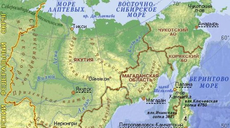
The territory of the Far East is located in 4 time zones. In time zone I (Kamchatka region and Chukotka Autonomous Okrug), the difference between local and world time is +12 hours. (between local and Moscow time +9 hours) In the II zone (Magadan region) the difference between local and world time is +11 hours. (+9 hours with Moscow). In III (Primorsky and Khabarovsk territories) this difference is +10 hours. (+7 hours compared to Moscow); in IV time zone (Republic of Sakha (Yakutia), Chita region) +9h. (+6 hours compared to Moscow). The Far East on the map of Russia is shown in Figure 1.
It is washed by the Laptev, East Siberian, Bering, Okhotsk and Japanese seas.
Fig.1.
Relief
The relief (Fig. 2.) of the Far East is elevated and even mountainous, which is the result of the structure of the lithosphere in this part of the planet. The fact is that the Far East is located at the junction of two large lithospheric plates. The result of this is active tectonic mobility of the territory. This especially applies to the eastern regions, the folding of which was formed during the Cenozoic. In this part of the planet, quite strong tremors still occur quite often.

Fig.2.
The south of the Far East is mainly dominated by low and medium-altitude mountain ranges, such as Bureinsky and Dzhugdzhur. In the north there are highlands (Kolyma, Chukotka) and plateaus (Anadyr), which arose as a result of volcanic activity. The mountain ranges located on the Kamchatka Peninsula stand out here.
Only a quarter of the territory of the Far East is occupied by plains. They are mainly located in those coastal areas where tectonic activity is low (West Kamchatka, North Sakhalin), as well as in intermountain depressions (Middle Amur, Anadyr, Central Kamchatka), so their area is relatively small. ……….The relief of the Far East was formed mainly in the Mesozoic and Cenozoic periods. It was then that folded zones and intermountain depressions appeared. The ocean had some influence on the formation of the relief. For example, the entire modern island of Sakhalin and the eastern slope was under water at that time. Only later did these areas appear on the surface, where they are still located.
From west to east, the character of the morphostructures of the Far East changes from more ancient to younger, and from folded-block to folded and block-folded. The highest parts of the mountains (the Dzhagdy, Bureinsky, Badzhalsky, Sikhote-Alin and others ridges) were occupied by glaciers in ancient times. Traces of this have been preserved in our time in the idea of various small landforms (hills, ravines and troughs).
Thus, as a result of various internal (tectonic) and external (glaciation, winds, ocean waters), Various types relief:
· erosion-denudation mid-mountain and low-mountain areas with areas of glacial landforms on Paleozoic and Mesozoic block-folded structures;
· erosion-denudation lowlands of Sikhote-Alin and Sakhalin on Mesozoic and Cenozoic folded-block and folded structures with lava plateaus;
· denudation-erosion strata plains of intermountain depressions of the Amur region;
· accumulative plains of intermountain depressions on Mesozoic and Cenozoic folded structures.
Depending on the nature of tectonic processes, the shapes of the relief on the surface also change. For example, on the Kuril Islands, under which the thickness of the earth’s crust reaches 15-20 kilometers, three elements of the tectonic structure are mainly developed. These are deep-sea trenches, island arcs and deep-sea trenches. Their formation was carried out sequentially. At the first stage, a deep-sea trench formed at the point of contact between the oceanic and continental plates. At the second stage, a marginal sea is formed, and then a rift basin is formed near the islands.
The relief of the Kamchatka Peninsula and the mainland of the country is a reflection of more ancient period. Continental and transitional (from oceanic to continental) prevail here. Earth's crust, block-folded structures, longitudinal-transverse deflections. In the relief of this territory, these features are expressed by lowlands and volcanic forms. Here, for example, is the intermountain Anadyr-Penzhina Plain.
The structure of Kamchatka and the Kuril Islands is mainly composed of Cretaceous and sedimentary rocks. In places of troughs, loose Neogene deposits are also present. Modern processes relief formations in the Far East are determined by tectonic processes and permafrost (in the northern part).
Active tectonic processes currently occurring in the Far East are the cause of various natural disasters. There are several active volcanoes and geysers in this area. Quite often, strong (up to 10 points) earthquakes and seaquakes occur in this part of the planet. The latter cause tsunamis - huge ocean waves. All these disasters lead to significant destruction and even casualties. Therefore, this part of Russia is the most unfavorable in terms of availability hazardous phenomena nature.
The southern half of the Far East is a mountainous country. Plains occupy an area three times smaller than mountains and are located in intermountain depressions, along sea coasts and valleys of large rivers.
As elsewhere, the relief of the Far East is the most important natural factor influencing human economic activity. The location of meadows, arable lands, hydropower systems of large industrial buildings, large cities directly depends on the shapes and types of terrain of the territory. Relief also influences the national economy indirectly, through other elements of the physical and geographical environment. For example, the Sikhote-Alin, Bureinsky, Dzhugdzhur ridges are barriers to air masses, and the intermountain Upper Zeya basin is an accumulator of cold air masses in winter. The distribution of soils, water resources, and the shape of river basins largely depend on the height and outline of the mountains. Finally, the dissected relief creates a variety of landscapes that are of great importance in the economic activities of the population.
The orography of the southern half of the Far East is complex, but some general patterns can be discerned in the distribution of mountain ranges, plateaus and intermountain plains. There is an alternation of the strikes of the northeastern and northwestern or even latitudinal ranges. Thus, located along the coast of the Sea of Japan and the Tatar Strait, the Sikhote-Alin ridge and (generally parallel to it) the Badzhalsky, Lesser Khingan, Bureinsky, Dusse-Alin and other ridges have a northeastern strike. This strike at a latitude of 53° changes to northwestern and latitudinal in the Tukuringra-Dzhagdy ridges and even further north in the Stanovoy Range, which is associated with the geological structure - the edges of the Precambrian plates. At latitude 56°, ridges of a meridional (northeast) direction can again be traced, in the systems of Southern Verkhoyansk and Dzhugdzhur. Here their orientation is associated with the edge of the Siberian plate. On the islands, a uniform northeastern strike of mountain ranges is noticeable, with a deviation to the meridional on Sakhalin. Numerous mountain ranges are separated by tectonic depressions.
Scheme of the surface structure of the south of the Far East...
The continental part of the southern half of the Far East is characterized by flattened peaks. Rare traces of glacial sculptural activity occur in the upper thirds of the slopes. Only on the Aldan-Okhotsk watershed and on the islands do the ridges have an alpine appearance: narrow ridges are formed by the closure of the walls of cirques and cirques. Volcanic landforms are developed on the Kuril Islands. In the south of the Khabarovsk Territory and in Primorye, extensive volcanic covers in the form of structural plateaus are observed. The structural forms include the Aldan Plateau - with a leveled surface, the Upper Allah Highlands - a denudation type of relief, individual granite massifs rise on the smoothed surface of slate mountains.
Most large plains in the Far East are located in the Amur basin. Thus, in the upper reaches of the Zeya, between the Stanovoy, Tukuringra-Dzhagdy and Dzhugdyr ridges, in a vast tectonic depression, the Upper Zeya Plain is located. The space from the mouth of the Zeya to the Lesser Khingan, including the lower reaches of the Zeya, Bureya and Arkhara rivers, is occupied by the Zeya-Bureya Plain; Below, in the middle reaches of the Amur and Sungari, the Amur-Sungari (Middle Amur) plain stretches, and in the upper reaches of the Ussuri, around Lake Khanka and along the Suifun River, the Suifuno-Khanka plain.
From the latitude of Komsomolsk to the north in the meridional direction, the Evoron-Chukchagir depression, occupied by a lacustrine-alluvial plain, extends.
On Sakhalin, an accumulative plain of complex genesis, formed by strata of marine, alluvial and lacustrine sediments, covers the northern third of the island, and the other (alluvial) extends meridionally along the Tym and Poronai rivers.
The Far Eastern mountains are mainly of medium altitude: the predominant heights are 1000 m and only individual ridges reach more than 2000 m.
The modern development of relief occurs under the influence of various exogenous physical and geographical processes, subject to the law of geographic zonation. They occur against the background of weak modern neotectonic movements in the western part of the territory and, on the contrary, against the background of violent movements and volcanism in the eastern part.
In the north, denudation associated with physical weathering, permafrost processes, erosion, colluvial, aeolian, organogenic and various accumulative processes are of great importance.
The mountains of the eastern outskirts are characterized by the formation of nival forms, as well as forms created by sea abrasion.
In the south, where there are no permafrost phenomena, the development of chemical and biological weathering is intensive. Here, significant areas have been developed by humans, and in areas where vegetation has been destroyed, deflation occurs during dry periods. In the eastern, coastal, part of the Far East, erosion acts in tandem with abrasion.
Physical weathering, which is the cracking and disintegration of massive bedrock resulting from the uneven heating or cooling of water in cracks, is most severe in areas devoid of vegetation, especially on char and on steep cliffs.
Physical weathering in combination with deluvial and permafrost processes ultimately leads to smoothing of slopes and peaks. If physical weathering acts in the alpine relief zone, eating away the rear parts of the cirques and cirques and narrowing the ridge separating them, then peaked relief forms are formed.
In areas of prolonged exposure to physical weathering, leveled upland surfaces can form, which then creates conditions for the formation of soil cover and the development of vegetation.
Since physical weathering manifests itself throughout the entire territory of the Far East and is of great practical importance in the economic development of the territory, during the construction of residential and industrial buildings in mountainous areas, it is necessary to take into account the physical weathering of the walls of the pit and the foundation on which the construction is being built. To avoid cracking of the soil, damage to buildings or their partial destruction in the Far East, it is necessary to use heat-insulating materials.
The impact of permafrost on the formation of various forms relief, and for the economic development of the region, since the territory on which it manifests itself is large in the Far East. In the central part of the Stanovoy Range, the maximum thickness of permafrost is 250 m; it is lower (120 m) in the foothills of the Dzhugdzhur and Stanovoy ridges and does not reach 60 m in the north of Bureinsky. The territories of the Kuril Islands, Sakhalin, the large near-valley part of the lower and middle Amur, the Ussuri basin and the coastal strip from the mouth of the Tumenjiang to 60° N are deprived of permafrost. w. The rest is covered by islands of permafrost.
The processes of sliding of a thawed horizon of loose sediments along a slope, the so-called solifluction, are widespread. The plastic mass usually moves, its sliding proceeds extremely slowly, intermittently and depends on sharp daily temperature fluctuations and the associated freezing and thawing of the strata. Solifluction manifests itself only on heated areas of slopes and on the surface of char.
When sediments slide, solifluction terraces are formed, which are easy to distinguish from alluvial ones: they are small in area, characterized by a bumpy surface, and the material composing them is not layered or sorted. Tiers of solifluction terraces are formed due to alternate thawing and freezing of the strata. Such terraces are widespread in the Aldan-Okhotsk watershed. The formation of mountain terraces is also associated with solifluction phenomena. We observed mountain terraces at an altitude of 1200 m in the Tukuringra-Dzhagdy ridge.
When developing terrace placers, as well as when digging pits in permafrost, solifluction processes can lead to floating and destruction of fastenings. In such areas, thermal insulating boards should be used as fastening materials. Special consideration should be given to solifluction processes, heaving mounds and ice formation when construction is located on slopes.
In the forest zone, the formation of permafrost mounds, the so-called hummocky relief forms, is highly developed. Sometimes group clusters of mounds of “burial grounds” in combination with the hollows separating them create a unique landscape of a “drunk forest”.
Along the shores of small lakes, as noted by S. L. Kushev, swelling of peat material forms a series of ridges. Peat bog mounds sometimes have a lens of subsoil ice inside; mounds with a mineral core are common in the Far East. Far Eastern “burial grounds” form numerous clusters both on plains and on gentle slopes. The heights of the mounds vary within 1 meter; diameter - several meters. The spaces between them are swampy or form oddly shaped open hollows. Often the surface of the mounds is crossed by frost cracks.
The process of formation of frozen mounds intensifies in those areas of soil where the normal conditions for the zone change. temperature conditions. The same thing happens when the temperature regime is artificially disrupted, i.e. during the construction of roads, bridges and buildings, during forest clearing and plowing. Therefore, it is necessary to develop measures to preserve permafrost or organize barrier zones at Far Eastern construction sites.
The permafrost development zone is characterized by thermokarst landscapes, which form at the site of forest fires and represent an alternation of narrow ridges and depressions. This difficult terrain can be defined as thermocarr fields. Due to uneven heating in these places, depressions, large sinkholes and sinkhole lakes are formed, which are not as regular in shape as karst lakes and are usually less deep. On slopes, rocks of heterogeneous composition form steps as a result of thermokarst.
In contrast to permafrost processes, which do not operate everywhere in the southern half of the Far East, river erosion and accumulation are developed everywhere, but act at different times and with unequal strength. In addition, the erosion and accumulation activities of rivers in the permafrost zone and beyond are very different. Thus, permafrost forms deep taliks under the beds of large rivers, prevents deep erosion only in places, but binds the banks, and in the presence of great activity, low terraces resist lateral erosion, yielding to it only in heated sunny areas.
The situation is different with small streams, in which local swelling of permafrost is observed under the bed, which serves as a significant obstacle to deep erosion (Kudryavtsev, 1939).
The northern and southern rivers differ greatly in the regime and size of the erosive activity of floods. Summer floods on the southern and eastern rivers of the Far East, despite the fact that they periodically have the character of catastrophic floods that completely fill the surface of a high floodplain, do not produce significant erosion, since it is usually secured by a thick turf. Significant erosion occurs on arable land, roads, etc.
Hollow waters erode arable land, carry away crops or cause them to become soaked in place. Erosion processes often disrupt transport connection, demolish bridges and thus make it difficult to remove crops from the fields.
Eolian landforms - dunes - are often associated with the floodplains of Far Eastern rivers. A distinctive feature of these dunes is that during their aeolian development there are long breaks when the dunes are partially or completely flooded with hollow water and are subject to varying degrees of erosion. Purely aeolian accumulative forms in the Far East are recorded only along the sea coast and along the shores of lakes.
Deep erosion can be traced along the Far Eastern rivers in close dependence on the nature and sign of modern vertical movements of a given section of the mountainous country.
Most large rivers in the southern part are characterized by the predominance of sandy or sandy-pebble channel alluvium and the formation of many branches with weak development of meanders. In the north these features are smoothed out.
Modern erosion of mountain slopes due to continuous turf proceeds very slowly, and only in places there are traces of catastrophic manifestations of storm erosion, when storm waters tear soil and trees from the slopes and the demolished material fills up areas of fields and vegetable gardens.
Gully erosion usually occurs in connection with human activity in places where the turf cover, which is particularly thick in the Far East, has been artificially destroyed. The exceptional density and thickness of the turf cover was noted by many researchers (Petrov B.F., 1960; Kachiyani, 1939; Liverovsky, Kolesnikov, 1949, etc.), who also pointed to its ability to withstand all kinds of erosion. Gullies grow mainly on arable lands, roads and roadside ditches, where the turf cover has been destroyed. In some places the gully network is so dense that it creates a badland type landscape.
Diluvial processes (as A.P. Pavlov understood them), i.e., the movement of loose material down the slope by rain or melted snow waters and, in the Far East, have local features (rain colluvium predominates over melt water). On the Aldan-Okhotsk watershed, on the slopes of northern exposure, deluvial washout is prevented by the high occurrence of permafrost. In the south, deluvial processes are hampered by exceptionally thick turf. Therefore, the colluvial movement of mineral particles occurs only in deeper soil horizons. A peculiarity of summer deluvial processes in the southern Far Eastern mountains is their periodicity, directly related to the rainfall regime and the alternation of dry and rainy years.
Screes in the mountains of the Far East have some zonal features. Their formation is more widespread on the Kuril Islands and in the mountains of the Aldan-Okhotsk watershed, where the alpine belt is larger and the slopes are weaker in vegetation than in the south.
Landslides are common in places where loose sediments develop, in the southern half and along the sea coasts.
In the southern half of the Far East there are many lakes and long sea coasts. The relief of the shores of lakes and sea reservoirs has unique features.
Wave activity is of great importance here. The territory of the Far East is characterized by abrasion - sea and lake.
As a result of marine abrasion, ledges (cliffs) and abrasion terraces (benches) are formed, which turn into plains when the coast rises.
Wave action must always be taken into account when constructing ports. If the planning is incorrect, port buildings can be destroyed by the action of sea waves.
The morphological types of the bottom of the seas adjacent to the territory of the Far East are diverse. They are expressed in the presence of an extensive continental shallow (in the northern and western, most of the Sea of Okhotsk) continental slope (along the eastern coast of the Kuril Islands). In the southeast it turns into a deep-sea trench. An underwater ridge can be traced under the Kuril ridge, and the Sea of Japan and the southern part of the Okhotsk Sea represent deep sea depressions.
Far Eastern karst is expressed slightly in the form of caves and niches - dissolution in areas of mountains composed of limestone. There are karst sinkholes and ravines that suddenly disappear down the slope into a funnel, lakes that constantly deepen due to the dissolution of the limestones of their bottom (Lake Taloe in Southern Verkhoyansk, etc.).
Widespread and exceptionally widespread development has the accumulation organic matter. It is specific to the Far East and imposes unique features on the general appearance of its nature.
In the south, among the organic types of relief, the most characteristic are sedge hummocks on horizontal surfaces (lake terraces, on the bottoms of river valleys, on structural plateaus). Here, organogenic processes create not only micro-, but also mesoforms of relief in the form of large ridges developed along the southern shore of Lake Khanka. This relief is created by dead horsetails and aquatic higher vegetation, collected in ridges, which are separated by areas of sedge lowland semi-passable swamps.
Mesoforms of organogenic origin include “woody alluvial deposits” (Chemekov Yu. F.), widespread along the banks of rivers in the forest zone and known as “creases”. Cracks are accumulations of tree trunks, roots and large branches.
From the above we can conclude that organogenic processes are clearly expressed on the low plains of the southern half of the Far East. In practice National economy Organogenic forms of relief are of no small importance, so intensive crease formation forces regular cleaning of the beds of navigable rivers, especially after floods.
The hummocky plains and flood plains are valuable hunting grounds. Drier hummocky plains are used for mowing and pasture.
Main types of relief. The Far East has a wide variety of relief types.
High mountainous terrain(over 2500 m) covers relatively small areas and is represented by: volcanic cones and volcanic ridges on the Kuril Islands.
Mid-altitude mountains(from 1000 to 2500 m) - much more widespread:
1) medium-altitude highlands and massifs with an alpine complex of forms, these include the Tarbaganakh and Uemlyakh massifs in Southern Verkhoyansk, etc.;
2) medium-altitude highlands and ridges with volcanic cones. These include the Lamanon Mountains on Sakhalin, mountain structures of the Kuril Islands;
3) medium-altitude folded ridges with traces of alpine forms or lacking them. These are the Bureinsky and Badzhalsky ridges, the West Sakhalin ridge, Sikhote-Alin, Setta-Daban, etc.
Lowlands(from 300 to 1000 m) covers significant areas in the Far East. This includes:
1) low foothill folded ridges that accompany the main systems of the Far East along the edges;
2) isolated areas of low mountains (island mountains). They end with the Western and Eastern Sakhalin Ranges (in the north), the southeastern foothills of the Lesser Khingan;
3) low-mountain massifs, which are intrusions - the Khorolsky and Grodekovsky massifs, Mount Shapka.
A special type of relief should be attributed effusive structural plateaus- Shufan and Maikha plateaus and others in the south of Primorye, in the Sikhote-Alin system, and individual plateaus in other mountain systems.
The plains of the Far East occupy smaller areas. They differ in origin, being divided into coastal and intermountain.
Among the coastal plains, the following are distinguished: 1) abrasion; 2) abrasion-accumulative of mixed genesis. Examples of an abrasion plain are the coastal lowlands on the Kuril Islands. The North Sakhalin Lowland can serve as an example of an abrasion-accumulative coastal plain.
Among the intermontane plains of the Far East, three types should be distinguished: alluvial, lacustrine-alluvial and glacial-alluvial.
Examples of purely alluvial plains are the Tym-Poronayskaya and Takaya-Susuyskaya plains on Sakhalin, as well as the Zeya-Burenskaya plain and others. The lacustrine-alluvial plains include the Prikhankai, Amur-Sungari, Evoron-Chukchagir and others. The glacial-alluvial plain in the south of the Far East is the Verkhne-Zeyskaya.
Different types of relief in the southern half of the Far East have different practical value and should be used for different economic purposes. Naturally, in practical activities, the relief is never assessed in isolation, in isolation from other components of the landscape, but still, in solving some problems, the nature of the relief can be decisive. Thus, to organize irrigated agriculture, a low, flat terrain is required; for fields of grain crops and potatoes - high drained plains. Low mountains and slopes of mid-altitude mountains are suitable for proper forestry, and in the very south for gardening; The highlands represent hunting grounds.
1) Using the map, study the geographical location of this region of Russia.
Think about the impact it has on the nature of the Far East.
The Far East occupies the extreme eastern position in the country. The region stretches from Chukotka to the Ussuri region. Northern regions The Far East lies beyond the Arctic Circle, and the southern ones lie at the latitude of the Mediterranean. The territory of the Far East consists of mainland, peninsular (Kamchatka, Chukotka) and island (Sakhalin, Kuril, Commander Islands, etc.). This geographical location provides a wide variety of natural conditions.
2) Determine the geographic coordinates of the extreme northern and southern points of the Far East, compare its latitudinal position with other territories of our country.
Its northernmost point is Cape Shelaginsky (700N, 1710E), the southernmost point is at the mouth of the Tyumen-Ula River (420N, 1300E). Compared to other regions of the country, the Far East covers a larger number of climatic zones and has a greater variety of conditions.
3) Which federal subjects are part of this region.
It consists of six administrative units: Primorsky, Khabarovsk and Kamchatka territories. Amur, Magadan and Sakhalin regions.
Questions in a paragraph
*Remember what resources the Pacific seas washing the shores of Russia are especially rich in.
The Pacific seas are especially rich in biological resources, are important as international sea routes, and have great recreational potential.
*Explain why in winter there are great contrasts between the temperatures of the coastal and inland regions of the Far East.
Coastal areas have a milder and wetter monsoon climate. Due to the peculiarities of the relief, moist air masses do not penetrate deep into the continent and a sharply continental climate is formed in the interior regions.
*Name the largest rivers flowing in the temperate zone of the Far East.
Lena, Yana, Indigirka, Kolyma.
Questions at the end of the paragraph
1. Indicate the most specific features of the geographical location of the Far East.
Extreme eastern position in the country and distance from other areas. The Far East has a large latitudinal elongation and a huge meridional elongation - along the entire Pacific coast of Russia. The region has a long coastline.
2. Tell us about the explorers of the Far East, name and show the geographical objects that bear their names.
In the 17th century, Russian expansion into Siberia and the Far East began. Yakutsk was founded in 1632. In 1647, the Cossacks, led by Semyon Shelkovnikov, founded a winter quarters on the shores of the Sea of Okhotsk, on the site of which Okhotsk, the first Russian port, is located today. IN mid-17th century centuries, Russian explorers such as Poyarkov and Khabarov from the Yakut fort went south to the Zeya and Amur rivers, where they encountered tribes that paid tribute to the Qing Empire (China), that is, who were Chinese citizens. As a result of the first Russian-Chinese conflict between Russia and the Qing Empire, the Treaty of Nerchinsk was concluded, according to which the Cossacks were to transfer to the Qing government the territories of the Albazin Voivodeship formed on the lands of the Daurs. The treaty determined the system of trade and diplomatic relations between states. The border between the countries under the Treaty of Nerchinsk in the north ran along the Gorbitsa River and the mountains of the watershed of the Amur Basin. The area of the coast of the Sea of Okhotsk between the Kivun and Taikan ridges remained undemarcated. IN late XVII century, Russian Cossacks Atlasov and Kozyrevsky began to explore the Kamchatka Peninsula, which at the beginning of the 18th century was included in the Russian Empire.
In 1724, Peter I sent the First Kamchatka Expedition to the peninsula, led by Vitus Bering. The expedition enriched Russian science with valuable information about the eastern coast of Siberia (in particular, the territory of today's Magadan and Kamchatka regions), new maps, and precise determinations of the coordinates of the Far Eastern coast, the Strait, which was later named the Bering Strait. In 1730 Russian government The Second Kamchatka Expedition was organized under the leadership of Bering and Chirikov with the task of reaching the shores of America (in particular the Aleutian Islands and Alaska). In the 18th century, Krasheninnikov, Steller, and Chichagov were engaged in exploration of Kamchatka.
In the 18th century, Old Believers and disgraced dignitaries, such as Golovkin, were exiled to Yakutia.
In the 19th century, Russian pioneers began active exploration of the Far East, which was greatly facilitated by the rapid weakening of the power of the Qing Empire, which in 1840 was drawn into the first Opium War. Fighting against the combined forces of England and France in the south of the country, in the areas of Macau and Guangzhou, drew upon themselves significant material and human resources. The northern regions of China were left practically without any cover, which Russia did not fail to take advantage of, which, along with other European powers, took an active part in the division of the decrepit Qing Empire. In 1850, Lieutenant G.I. Nevelskoy landed at the mouth of the Amur and established a military post there on his own. Convinced that the Qing administration, which by that time had not recovered from the consequences of the first Opium War and was bound in its actions by the Taiping uprising that broke out in the country, did not have the opportunity to adequately respond to the territorial claims of Russia, Nevelskoy decided to declare the mouth of the Amur and the coast of the Tartar Strait the possessions of the Russian Empire. . 14 May 1854 - Governor General Eastern Siberia, Count N.N. Muravyov, having received data from G.I. Nevelsky about the absence of Qing military units along the Amur, organized the first rafting on the river, which included: the steamer "Argun", 48 boats, 29 rafts and about 800 people . The rafting delivered ammunition, food, and troops (hundreds of Cossacks, 2nd Cavalry Brigade of the Transbaikal Army) to the lower reaches of the Amur. Some of the troops then went by sea to Kamchatka to strengthen the Peter and Paul garrison, while some remained on Chinese territory to implement Ant’s project for the development of the Amur region.
A year later, the second rafting took place, in which about 2.5 thousand people took part. By the end of 1855, there were already five Russian settlements in the lower reaches of the Amur: Irkutskoye, Bogorodskoye, Novo-Mikhailovskoye, Sergeevskoye. In 1858, the right bank of the Amur officially ceded to Russia under the Aigun Treaty concluded with the Qing Empire.
3. Give a description of the relief of the Far East.
Almost the entire territory of the Far East belongs to the areas of Cenozoic folding. And in the extreme east, the earth’s crust is especially unstable, and the disturbances continue in our time. The relief of the Far East is mainly mountainous. This is an earthquake and tsunami area, a seismic zone. In the south, medium-high and low mountains predominate (Sikhote-Alin), on the Kamchatka Peninsula there are high mountains (volcanoes) (Klyuchevskaya Sopka - 4750 m), there are areas with flat terrain (Central Kamchatka Plain - intermountain depression), there is also the Kolyma Highlands, Anadyr plateau.
4. Why does the distribution of soils in the Far East differ from the zonation scheme of the Russian Plain?
The formation of certain soils is related to the relief and climate. Soils are distributed in natural areas. Climate, relief, natural areas(their areas and distribution) of the Russian Plain and the Far East are different, therefore the zonal distribution of soils is different.
The Far East is the most remote region from the central part of Russia. It consists of 9 subjects, the population density of which is unevenly distributed. They all differ from each other in climate and geological structure. These factors are greatly influenced by the terrain.
General features: tectonic structure of the Far East
The territory of the Far East stretches along the Pacific coast of Russia for 4,500 km. It is located in the contact zone of lithospheric plates (the Siberian Platform and the Pacific folding area), folding processes are still underway here. Due to the special structure of the lithospheres this area mountainous and undulating. In the Far East, earthquakes and seaquakes occur more often than in other regions, which are accompanied by the formation of tsunamis, and volcanism is observed.
In Kamchatka there is the most powerful volcano in Eurasia - the famous Klyuchevskaya Sopka.

Rice. 1. Klyuchevskaya Sopka.
Mountains of the Far East
Despite the fact that most of the Far East is covered with mountains, there are not many truly large mountain systems. Here are some of them:
- Sikhote-Alin – the largest mountain system in the region. It lies on the territory of Khabarovsk and Primorsky Territories. The highest mountain of this massif is Tordoki-Yani, whose height is 2090 meters.

Rice. 2. Sikhote-Alin mountain system.
- Suntar-Hayata - a mountain range located on the territory of Yakutia and Khabarovsk Territory. The most large mountain in this mountain range - Mus-Khaya. its height is 2959 meters.
- Verkhoyansk chains – are located on the territory of Yakutia and extends over 1200 km. The chain includes the Orulgan ridge, the Kular and Kharaulakh ridges.
- Dzhugjur – mountains of the Khabarovsk Territory with a length of 700 km. maximum height Mount Topko has a height of 1906 meters.
Volcanoes of the Far East
The territory of the Far East is famous for the fact that it is here that a large number of active volcanoes are concentrated, including the largest volcano in Eurasia - Klyuchevskaya Sopka.
Klyuchevskaya Sopka - the age of the volcano is approximately 7000 years, and it is located on the Kamchatka Peninsula. Another large active volcano is Shiveluch.
TOP 2 articleswho are reading along with this

Rice. 3. Shiveluch Volcano.
The height of the volcano is 3283 meters.
Not far from Klyuchevskaya Sopka there is the Bezymyanny volcano, which is active and has a height of 2882 meters. Also among the rather large volcanoes is Karymskaya Sopka. It has a height of 1468 meters, and its crater constantly releases hot gases.
On the territory of Kamchatka there is the Valley of Geysers - the largest collection of geysers in Eurasia.
Evaluation of the report
Average rating: 4.3. Total ratings received: 11.
The East is not only one of the four cardinal directions. This is also the name for a large macroregion of the planet, which has a special culture and is opposed to the so-called Western world. It consists of three parts: the Near, Middle and Far East. The relief, climate, natural resources and cities of the last of these regions will be discussed in our article.
Far East on the map
The Far East most often refers to the eastern expanses of Russia adjacent to the Pacific Ocean, which stretches from the Chukotka Peninsula in the north to the Primorsky Territory in the south. The area of the region is over 6 million square meters. km, which is approximately 36% of the total territory of the country.
In a broader interpretation, the Far East also covers the countries of East and Southeast Asia, including the islands of the Sunda archipelago.
Administratively, the Russian Far East coincides with the borders of the Far Eastern Federal District. It includes nine federal subjects (the marks on the map correspond to the numbers from the list). This:
- Chukotka Autonomous Okrug.
- The Republic of Sakha (Yakutia).
- Kamchatka Krai.
- Magadan Region.
- Khabarovsk region.
- Amur region.
- Primorsky Krai.
- Jewish Autonomous Region.
- Sakhalin region.
Time zones of the Far East: UTC+9, UTC+10, UTC+11 and UTC+12. The time difference with Moscow in this region is 6, 7, 8 and 9 hours, respectively.
From north to south, the territory of the Far East stretches for 4,500 kilometers, from west to east - almost 3,500 kilometers. Thus, the southern extremities of the region are located at the latitude of Sofia, Rome and Toulouse, while its northern outskirts are far beyond the Arctic Circle. Due to such extensive geographical location, climate, natural resources and topography of the Far East are exceptionally diverse.
Climate and inland waters
The climatic features of the region are particularly contrasting. Thus, in Chukotka the “frosty” subarctic climate prevails, in Yakutia it is sharply continental, but in the Primorsky Territory it is monsoon. In the Far North, winters are harsh, with little snow and long (up to nine months in a row). The complex and predominantly mountainous terrain has a significant influence on the climate of the region.
During the cold season, most of the Far East experiences heavy precipitation (rain, snowfall, blizzards). This can be explained simply: winters are cold air currents from the so-called Asian low mix with warm air masses from the Pacific Ocean, forming a large number of cyclones. Particularly heavy snowfalls occur in Kamchatka and Sakhalin. Sometimes the height of the snow cover here reaches 5-6 meters!
In summer, heavy monsoon rains occur in the southern and southeastern parts of the region, as a result of which the largest Far Eastern river, the Amur, very often overflows its banks, leading to catastrophic consequences. At the same time of year, the Pacific coast often suffers from strong typhoons coming from the south.
The river network of the Far East is dense and well developed. The region's watercourses are usually full of water and often overflow their banks during rains. The longest river in the Far East is the Lena. It begins on the slopes of the Baikal ridge and flows into the Laptev Sea, forming a vast multi-branch delta.

There are also many lakes in the Far East. Most often they are located in lowlands, as well as in zones of active volcanism. The largest lake in the region is Khanka, located on the border of Primorsky Krai and the Chinese province of Heilongjiang.
Relief of the Far East: general features
The region's terrain is predominantly mountainous. Plains and lowlands occupy only about 25% of its territory. This is a land of volcanoes, earthquakes and seismically active zones. Another feature of the local terrain is its rather complex coastline.
The following natural and geological factors had a significant influence on the formation of the relief of the Far East in its current appearance:
- Quaternary glaciations (there were two of them).
- Active physical weathering of rocks.
- Permafrost processes (especially solifluction).

The local landscapes may seem unusual and even a little “unearthly”. The mountains and highlands here are smooth, soft, without expressive ridges or canyons. However, the closer to the Ocean shore, the more often there are pointed rocks and steep cliffs. Also typical of this area are the plateau plains stretching along the Amur river valley and its largest tributaries.
Mountains of the Far East
There are plenty of mountains in this region. But many of them are low or medium in absolute height. The largest mountain systems of the Far East include:
- Sikhote-Alin.
- Suntar-Hayata.
- Verkhoyansk chains.
- Dzhugjur.
- Chersky Ridge.
- Middle and Eastern ranges of Kamchatka.
Sikhote-Alin is the largest mountainous country in the Far East by area. It stretches for almost 1200 km within the Khabarovsk and Primorsky Territories. The highest point of the massif is Mount Tordoki-Yani (2090 meters). The Sikhote-Alin mountain system is extremely heterogeneous. Its northern part is represented by gently sloping forested peaks of a rounded shape, but the southern part, on the contrary, has a highly dissected topography, with numerous gorges, rocky outcrops and stone screes.
The Kamchatka Peninsula is rich in volcanoes, of which there are at least three hundred. The largest and most famous of them is Klyuchevskaya Sopka. This is the highest mountain in the Far East and the Asian part of Russia as a whole. Its absolute height is constantly changing: after the last eruption in 2013, it is 4835 meters above sea level. It is worth noting that the unique and incredibly beautiful volcanoes of Kamchatka are included in the UNESCO World Heritage List.

Natural resources of the region
The Far East is extremely rich in various natural resources (in particular, minerals), which allows the region to occupy a significant place in the country's economy. What does not lie in its depths! These are gold, nickel, tin, diamonds, manganese, polymetallic and manganese ores, oil, gas, hard and brown coal, and phosphorites. True, due to the vast territory, harsh climatic conditions and low population of the region, all these resources are practically undeveloped.
The reserves of forest resources in the Far East are huge and diverse. Their total volume is estimated by experts at approximately 11 billion cubic meters wood It is important to note that the forestry and fishing industries, as well as the mining of non-ferrous metals, account for over 50% of all marketable products in the region.
Population and cities of the Far East
The population of this region is extremely small. The following fact will help you understand how much: almost twice as many people live in Moscow alone as in the entire Far East. Despite the fact that this region is larger in area than Western Europe. Today, about 6.3 million people live within its borders.
The five largest cities in the Far East include:
- Khabarovsk.
- Vladivostok.
- Yakutsk
- Komsomolsk-on-Amur.
- Blagoveshchensk

Today, the Far East leads Russia in depopulation processes. Moreover, everything is in order with the birth rate in the region. The main reason for demographic decline is the colossal outflow of the population to other regions or countries. Scientists' forecasts in this regard are disappointing: by 2050, the population of the Far East may decrease to 4 million people.
As a solution to the demographic problem in the region, experts propose many measures: reducing prices for public utilities, activation of social and cultural life, etc. Among the most exotic options is the proposal to move the capital from Moscow to one of the Far Eastern cities.