Coats of arms of the provinces of the Russian Empire. Administrative-territorial division of the Russian Empire Map of the Russian Empire in 1900 with provinces
Read also
Along with the collapse of the Russian Empire, the majority of the population chose to create independent national states. Many of them were never destined to remain sovereign, and they became part of the USSR. Others were incorporated into the Soviet state later. What was the Russian Empire like at the beginning? XXcentury?
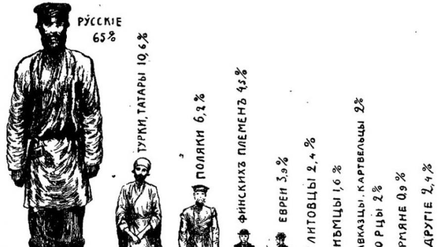
By the end of the 19th century, the territory of the Russian Empire was 22.4 million km 2. According to the 1897 census, the population was 128.2 million people, including the population of European Russia - 93.4 million people; Kingdom of Poland - 9.5 million, - 2.6 million, Caucasus Territory - 9.3 million, Siberia - 5.8 million, Central Asia - 7.7 million people. Over 100 peoples lived; 57% of the population were non-Russian peoples. The territory of the Russian Empire in 1914 was divided into 81 provinces and 20 regions; there were 931 cities. Some provinces and regions were united into governorates-general (Warsaw, Irkutsk, Kiev, Moscow, Amur, Stepnoe, Turkestan and Finland).
By 1914, the length of the territory of the Russian Empire was 4383.2 versts (4675.9 km) from north to south and 10,060 versts (10,732.3 km) from east to west. The total length of the land and sea borders is 64,909.5 versts (69,245 km), of which the land borders accounted for 18,639.5 versts (19,941.5 km), and the sea borders accounted for about 46,270 versts (49,360 .4 km).
The entire population was considered subjects of the Russian Empire, the male population (from 20 years old) swore allegiance to the emperor. The subjects of the Russian Empire were divided into four estates (“states”): nobility, clergy, urban and rural inhabitants. The local population of Kazakhstan, Siberia and a number of other regions were distinguished into an independent “state” (foreigners). The coat of arms of the Russian Empire was a double-headed eagle with royal regalia; the state flag is a cloth with white, blue and red horizontal stripes; The national anthem is “God Save the Tsar.” National language - Russian.
Administratively, the Russian Empire by 1914 was divided into 78 provinces, 21 regions and 2 independent districts. The provinces and regions were divided into 777 counties and districts and in Finland - into 51 parishes. Counties, districts and parishes, in turn, were divided into camps, departments and sections (2523 in total), as well as 274 landmanships in Finland.
Territories that were important in military-political terms (metropolitan and border) were united into viceroyalties and general governorships. Some cities were allocated into special administrative units - city governments.
Even before the transformation of the Grand Duchy of Moscow into the Russian Kingdom in 1547, at the beginning of the 16th century, Russian expansion began to expand beyond its ethnic territory and began to absorb the following territories (the table does not include lands lost before the beginning of the 19th century):
|
Territory |
Date (year) of accession to the Russian Empire |
Data |
|
Western Armenia (Asia Minor) |
The territory was ceded in 1917-1918 |
|
|
Eastern Galicia, Bukovina (Eastern Europe) |
ceded in 1915, partially recaptured in 1916, lost in 1917 |
|
|
Uriankhai region (Southern Siberia) |
Currently part of the Republic of Tuva |
|
|
Franz Josef Land, Emperor Nicholas II Land, New Siberian Islands (Arctic) |
The archipelagos of the Arctic Ocean are designated as Russian territory by a note from the Ministry of Foreign Affairs |
|
|
Northern Iran (Middle East) |
Lost as a result of revolutionary events and the Russian Civil War. Currently owned by the State of Iran |
|
|
Concession in Tianjin |
Lost in 1920. Currently a city directly under the People's Republic of China |
|
|
Kwantung Peninsula (Far East) |
Lost as a result of defeat in the Russo-Japanese War of 1904-1905. Currently Liaoning Province, China |
|
|
Badakhshan (Central Asia) |
Currently, Gorno-Badakhshan Autonomous Okrug of Tajikistan |
|
|
Concession in Hankou (Wuhan, East Asia) |
Currently Hubei Province, China |
|
|
Transcaspian region (Central Asia) |
Currently belongs to Turkmenistan |
|
|
Adjarian and Kars-Childyr sanjaks (Transcaucasia) |
In 1921 they were ceded to Turkey. Currently Adjara Autonomous Okrug of Georgia; silts of Kars and Ardahan in Turkey |
|
|
Bayazit (Dogubayazit) sanjak (Transcaucasia) |
In the same year, 1878, it was ceded to Turkey following the results of the Berlin Congress. |
|
|
Principality of Bulgaria, Eastern Rumelia, Adrianople Sanjak (Balkans) |
Abolished following the results of the Berlin Congress in 1879. Currently Bulgaria, Marmara region of Turkey |
|
|
Khanate of Kokand (Central Asia) |
Currently Uzbekistan, Kyrgyzstan, Tajikistan |
|
|
Khiva (Khorezm) Khanate (Central Asia) |
Currently Uzbekistan, Turkmenistan |
|
|
including Åland Islands |
Currently Finland, the Republic of Karelia, Murmansk, Leningrad regions |
|
|
Tarnopol District of Austria (Eastern Europe) |
Currently, Ternopil region of Ukraine |
|
|
Bialystok District of Prussia (Eastern Europe) |
Currently Podlaskie Voivodeship of Poland |
|
|
Ganja (1804), Karabakh (1805), Sheki (1805), Shirvan (1805), Baku (1806), Kuba (1806), Derbent (1806), northern part of the Talysh (1809) Khanate (Transcaucasia) |
Vassal khanates of Persia, capture and voluntary entry. Secured in 1813 by a treaty with Persia following the war. Limited autonomy until the 1840s. Currently Azerbaijan, Nagorno-Karabakh Republic |
|
|
Imeretian kingdom (1810), Megrelian (1803) and Gurian (1804) principalities (Transcaucasia) |
Kingdom and principalities of Western Georgia (independent from Turkey since 1774). Protectorates and voluntary entries. Secured in 1812 by a treaty with Turkey and in 1813 by a treaty with Persia. Self-government until the end of the 1860s. Currently Georgia, Samegrelo-Upper Svaneti, Guria, Imereti, Samtskhe-Javakheti |
|
|
Minsk, Kiev, Bratslav, eastern parts of Vilna, Novogrudok, Berestey, Volyn and Podolsk voivodeships of the Polish-Lithuanian Commonwealth (Eastern Europe) |
Currently, Vitebsk, Minsk, Gomel regions of Belarus; Rivne, Khmelnitsky, Zhytomyr, Vinnitsa, Kiev, Cherkassy, Kirovograd regions of Ukraine |
|
|
Crimea, Edisan, Dzhambayluk, Yedishkul, Little Nogai Horde (Kuban, Taman) (Northern Black Sea region) |
Khanate (independent from Turkey since 1772) and nomadic Nogai tribal unions. Annexation, secured in 1792 by treaty as a result of the war. Currently Rostov region, Krasnodar region, Republic of Crimea and Sevastopol; Zaporozhye, Kherson, Nikolaev, Odessa regions of Ukraine |
|
|
Kuril Islands (Far East) |
Tribal unions of the Ainu, bringing into Russian citizenship, finally by 1782. According to the treaty of 1855, the Southern Kuril Islands are in Japan, according to the treaty of 1875 - all the islands. Currently, the North Kuril, Kuril and South Kuril urban districts of the Sakhalin region |
|
|
Chukotka (Far East) |
Currently Chukotka Autonomous Okrug |
|
|
Tarkov Shamkhaldom (North Caucasus) |
Currently the Republic of Dagestan |
|
|
Ossetia (Caucasus) |
Currently the Republic of North Ossetia - Alania, the Republic of South Ossetia |
|
|
Big and Small Kabarda |
Principalities. In 1552-1570, a military alliance with the Russian state, later vassals of Turkey. In 1739-1774, according to the agreement, it became a buffer principality. Since 1774 in Russian citizenship. Currently Stavropol Territory, Kabardino-Balkarian Republic, Chechen Republic |
|
|
Inflyantskoe, Mstislavskoe, large parts of Polotsk, Vitebsk voivodeships of the Polish-Lithuanian Commonwealth (Eastern Europe) |
Currently, Vitebsk, Mogilev, Gomel regions of Belarus, Daugavpils region of Latvia, Pskov, Smolensk regions of Russia |
|
|
Kerch, Yenikale, Kinburn (Northern Black Sea region) |
Fortresses, from the Crimean Khanate by agreement. Recognized by Turkey in 1774 by treaty as a result of war. The Crimean Khanate gained independence from the Ottoman Empire under the patronage of Russia. Currently, the urban district of Kerch of the Republic of Crimea of Russia, Ochakovsky district of the Nikolaev region of Ukraine |
|
|
Ingushetia (North Caucasus) |
Currently the Republic of Ingushetia |
|
|
Altai (Southern Siberia) |
Currently, the Altai Territory, the Altai Republic, the Novosibirsk, Kemerovo, and Tomsk regions of Russia, the East Kazakhstan region of Kazakhstan |
|
|
Kymenygard and Neyshlot fiefs - Neyshlot, Vilmanstrand and Friedrichsgam (Baltics) |
Flax, from Sweden by treaty as a result of the war. Since 1809 in the Russian Grand Duchy of Finland. Currently Leningrad region of Russia, Finland (region of South Karelia) |
|
|
Junior Zhuz (Central Asia) |
Currently, the West Kazakhstan region of Kazakhstan |
|
|
(Kyrgyz land, etc.) (Southern Siberia) |
Currently the Republic of Khakassia |
|
|
Novaya Zemlya, Taimyr, Kamchatka, Commander Islands (Arctic, Far East) |
Currently Arkhangelsk region, Kamchatka, Krasnoyarsk territories |
FEDERAL AGENCY FOR EDUCATION
State educational institution
higher professional education
KOVROV STATE UNIVERSITY
Department of History
in the discipline: History of the Vladimir region.
on the topic: “Vladimir province of the 19th century.”
Completed:
student gr. A5-1
Ivanov I.I.
Vladimir 2010
Abstract plan:
1. The village of Andreevskoye is the patrimony and estate of the Vorontsovs.
2. The first governors of the Vladimir province.
3. Patriotic War of 1812 and the Vladimir region.
5. Literature.
1. The village of Andreevskoye - patrimony and estate of the Vorontsovs.
In the 40-60s of the 18th century. Enlightenment ideas penetrate into Russia. The Enlightenment was a broad ideological movement. In accordance with the theory of the Enlightenment, all people are free and equal, they should all have the right of property, the land should belong to the one who cultivates it. These ideals were most fully embodied in the views of A. N. Radishchev.
Among the educated nobility of this period, one can distinguish another movement close to Enlightenment ideas - liberal-conservative.
One of the representatives of such liberal nobility was Roman Illarionovich (Larionovich) Vorontsov, the first governor of Vladimir. He was one of the founders of the Free Economic Society, founded in Russia in 1765.
The son of Roman Larionovich, Alexander Romanovich Vorontsov, a famous statesman, since 1773 - president of the College of Commerce, was familiar with figures of the French Enlightenment, in particular Voltaire, and supported educational ideas. In 1778, A. N. Radishchev began working at the Commerce Collegium, with whom A. R. Vorontsov was a member of the Urania Masonic lodge. The attitude towards autocracy and serfdom among A. Vorontsov and A. Radishchev largely coincided. After the arrest of A. Radishchev and his death sentence, A. R. Vorontsov, together with other prominent people, signed a petition to Catherine II to change the punishment. The Empress replaced the death penalty with 10 years of exile in Siberia.
In the Vladimir province, A. R. Vorontsov owned the Andreevskoye estate in Pokrovsky district. This was the Vorontsov family estate. Noble estates, as a special complex, appeared in the second half of the 18th century, more precisely, after the decree of 1762, which exempted nobles from compulsory public service. This decree made it possible for the nobility to return to their estates and engage in farming.
The estate arose as a residential and economic complex, then gradually turned into a cultural center. It combined the family traditions of the nobility, the way of peasant village life, the cultural traditions of Western Europe, architectural monuments were created here, park ensembles were formed, theaters and art galleries arose. The architectural and artistic appearance of the Andreevskoye estate took shape in the second half of the 18th century. The village of Andreevskoye (now Petushinsky district) was located near the small river Nergel, which flowed into Peksha. The estate included a huge count's house on three floors, with outbuildings, outbuildings, as well as a garden and greenhouses where oranges, lemons, and pineapples were grown. In 1772, instead of the old wooden rural church, a new stone church was built, and construction of a school and almshouse was underway. The house was surrounded by a park, laid out in the French or regular style, with a clear layout of alleys, lawns, and strictly selected tree species.
In 1789, A. Vorontsov decided to create a theater in Andreevsky, to house which the reconstruction of the house was undertaken. Serfs played in the theater - 65 actors, 38 musicians, 13 dancers and “dancing women”. The interior decoration of the palace was distinguished by exceptional splendor. In the state rooms with parquet floors, oak panels were made, “the capitals, vases, garlands, near the mirrors” were gilded, and paintings were placed in special stamps. The walls of some rooms were covered with fabrics - “Volodimersky motley.” The palace was heated with tiled stoves, for the decoration of which over 3 thousand tiles were brought from Gzhel.
Of particular interest is the portrait gallery, which was formed over a number of decades. By the beginning of the 19th century. the collection consisted of 284 works, among which were 22 royal portraits. A number of portraits are associated with the name of one of the famous artists of the 18th century. D. G. Levitsky. It is known that A. R. Vorontsov paid D. Levitsky sums of money for the portrait of Semyon Vorontsov (brother of A. R. Vorontsov). Ekaterina Romanovna Dashkova (daughter of R.L. Vorontsov, married to Dashkova, director of the St. Petersburg Academy of Sciences and president of the Russian Academy) often came to the estate.
2. The first governors of the Vladimir province.
In 1708 Russia was divided into eight provinces. November 7, 1775 a manifesto “Institutions for the management of the provinces of the All-Russian Empire” was published, on the basis of which the entire territory was divided into 50 provinces with a population of 300-400 thousand people in each; in turn, in the provinces, districts with a population of 20-30 thousand were allocated. The regional administration was headed by a viceroy or governor-general, ruling two or three provinces, each of which was headed by a governor. By decree of September 1, 1778 The Vladimir governorship was established, consisting of the Vladimir, Tambov and Penza provinces. The same decree ordered the governor, Count R.L. Vorontsov, to travel around the entire territory of the newly created Vladimir province and divide it into districts. There were 14 districts in the province: Vladimirsky, Alexandrovsky, Vyaznikovsky, Gorokhovetsky, Kirzhachsky, Kovrovsky, Melenkovsky, Muromsky, Pereslavl-Zalessky, Pokrovsky, Sudogodsky, Suzdal, Yuryev-Polsky. Ancient Russian lands entered the Vladimir province. The organs of noble self-government began to take shape before the exit
"Certificate of Complaint." The first elections of the provincial leader of the nobility in Vladimir took place in 1778. The large landowner F.A. Apraksin was elected leader, who held this position until 1787 and was elected three times. Subsequently, the leaders were re-elected every three years: in 1788-1790. - F.I. Novikov, 1791-1793 - E. F. Kudryavtsev, 1794-1796. - A.D. Taneev, 1797-1799 - E. M. Yazykov, 1800-1802. - A. A. Kuzmin-Karavaev. The responsibilities of the provincial leader were complex: presence in the Order of Public Charity and supervision of its charitable institutions, participation in the recruitment of recruits, supervision of roads and the supply of post horses to stations, control of the distribution of taxes to the treasury from landowner peasants. To fulfill them, he had to travel a lot and conduct extensive correspondence. According to Kuzmin-Karavaev’s calculations, all this required about 200 rubles. in year. But the leader had neither government nor public funds at his disposal, and covered all expenses for his service from his own funds. The leaders did not receive any salary. The district leaders of the nobility also performed duties on a voluntary basis. Of course, not all of them performed public service conscientiously. As a rule, they lived on their estates, visiting the city for “some urgent needs.” Until the end of the 18th century. nobles did not have the right to refuse the position of leader. Nevertheless, they found ways to avoid it, citing illness, poverty or illiteracy (“poor literacy”). The nobles were equally reluctant to take up other free elective positions. Therefore, the Vladimir viceroyal government issued a special decree obliging conscientious objectors to undergo a medical examination. But the same impoverished nobles willingly took elected paid positions. The main responsibility of the deputy assembly was to compile a genealogical book of the province. District leaders presented alphabetical lists of all nobles who owned real estate in their districts. However, being included in these lists did not mean that the clan would be included in the genealogical book. Only after the presentation and analysis of evidence in the deputy meeting and by its decision (at least 2/3 of the votes) was the clan entered into the genealogical book. In the 80-90s of the 18th century. 145 noble families were entered in the genealogical book of the Vladimir province.
3. Patriotic War of 1812 and the Vladimir region.
In the summer of 1812, misfortune struck Russia. Napoleon's hordes invaded its borders. The Patriotic War began. At the beginning of September, Moscow was abandoned. The Vladimir province became the closest rear of the fighting Russian army. It served as a base where recruits recruited from different provinces gathered and trained, and army reserve regiments were formed. Recruitment sets followed one after another. During the first decade of the 19th century. 10 sets were carried out. Two recruitments took place in 1811 and the first half of 1812. After the Battle of Borodino, the creation of a trained reserve acquired particular urgency. The next recruitment was announced: 2 recruits from every hundred of the tax-paying population. Recruits were to be concentrated in 13 points, including 40 thousand in the Vladimir province.
According to rough estimates, about 80 thousand Vladimirites were in the active army, participated in the battle of Smolensk, near Krasnoye, at Borodino, Maloyaroslavets, and in foreign campaigns. More than half of them died in battles, died from wounds and illnesses. Hospitals were established in Vladimir, county towns, and a number of rural settlements. Some landowners opened hospitals on their estates of their own free will and at their own expense. And the commander of the combined grenadier division, Major General Count Mikhail Semenovich Vorontsov, owner of the village of Andreevskoye, took part in the Battle of Borodino. His division covered itself with unfading glory, defending the famous
, Ukrainian state and Ukrainian SSR. The head of the province is the governor.
Initial division under Peter I
Division of Russia into provinces in 1708
Until 1708, the territory of the Russian state was divided into counties of different sizes and status (former princely lands, appanages, orders, etc.) and categories.
The first 8 provinces were formed during the Regional Reform, by decree of Peter I of December 18 (29), 1708:
- Ingria (in 1710 transformed into St. Petersburg) - it was headed by Alexander Danilovich Menshikov;
- Moscow - Tikhon Nikitich Streshnev;
- Arkhangelogorodskaya - Pyotr Alekseevich Golitsyn;
- Smolenskaya - Pyotr Samoilovich Saltykov;
- Kyiv - Dmitry Mikhailovich Golitsyn;
- Kazanskaya - Pyotr Matveevich Apraksin;
- Azovskaya - Fedor Matveevich Apraksin;
- Siberian - Matvey Petrovich Gagarin.
During the reform, all counties were abolished, and provinces were made up of cities and adjacent lands. As a result, the boundaries of the provinces were quite arbitrary. The provinces were headed by governors or governors general, who performed administrative, police, financial, and judicial functions. Governors-General were also commanders of troops in the provinces under their control. In 1710-1713, the provinces were divided into shares governed by the Landrat. In 1714, Peter I issued a decree, according to which shares became a unit of local government, and the landrat was elected by local nobles. However, in fact, this order was not carried out; the Senate confirmed the Landrat on the lists submitted by the governors.
Second reform of Peter I
In 1719, Peter I carried out a reform of the administrative division. The provinces were divided into provinces, and the provinces, in turn, into districts. The province was headed by a voivode, and the district was headed by a zemstvo commissar. According to this reform, the province became the highest regional unit of the Russian Empire, and the provinces played the role of military districts. Provincial governors reported to the governors only in military matters; in civil matters, the governors reported only to the Senate.
In 1719, the Nizhny Novgorod province was restored, and the Revel province and 47 provinces were established on the newly acquired lands in the Baltic states. The Astrakhan and Revel provinces were not divided into provinces. Until 1727, the administrative-territorial division of the country did not undergo significant changes. Minor changes include the renaming of the Azov province to Voronezh in 1725 and the restoration of the Smolensk province in 1726.
Reform of 1727
In 1727, the administrative-territorial division was revised. Districts were abolished and uyezds were reintroduced instead. The boundaries of the “old” districts and the “new” counties in many cases coincided or almost coincided. Belgorod (split from Kyiv) and Novgorod (split from St. Petersburg) provinces were formed.
Subsequently, until 1775, the administrative structure remained relatively stable with a tendency towards disaggregation. Gubernias were formed mainly in newly acquired (reconquered) territories; in some cases, several provinces of old provinces were separated into new ones. By October 1775, the territory of Russia was divided into 23 provinces, 62 provinces and 276 districts (the number of districts in the Novorossiysk province is unknown and is not included in the total number).
Reorganization under Catherine II

Coats of arms of the provinces of the Russian Empire
On November 7, 1775, Catherine II issued a decree “Institutions for the management of provinces,” according to which a radical reform of the administrative-territorial division of the Russian Empire was carried out in 1775-1785. In accordance with this decree, the size of the provinces was reduced, provinces were eliminated and the division of counties was changed. The new administrative-territorial division grid was drawn up so that 300-400 thousand people lived in the province, 20-30 thousand people lived in the district. Most of the new administrative-territorial units, with rare exceptions, received the official name “governorship”. The governorships, which were extensive in territory, were divided into regions. An additional impetus for the reform was the need to strengthen local central power after the Peasant War under the leadership of E. I. Pugachev.
In 1785, after the completion of the reform, the Russian Empire was divided into 38 governorships, 3 provinces and 1 region (Tauride) with the rights of governorship. In addition, the empire included the Housing of the Don Cossacks, in which there was Cossack self-government.
Several governorships were governed by one governor-general, and the governor of the governorship itself was appointed to the governorship (viceroy or governor), in addition, a body of noble self-government was formed in the governorship - the provincial noble assembly, headed by the provincial leader of the nobility. Viceroys and governors were subordinate to the Senate and prosecutorial supervision, headed by the Prosecutor General. The district was headed by a police captain, who was elected once every 3 years by the district assembly of nobles. The governor-general was appointed personally by the empress and had unlimited power in the governorships entrusted to him. Thus, an emergency management regime was actually introduced throughout the Russian Empire. Subsequently, until 1796, the formation of new governorships occurred mainly as a result of the annexation of new territories.
By the end of the reign of Catherine II (November 1796), the Russian Empire included 48 governorships, 2 provinces, 1 region, as well as the lands of the Don and Black Sea Cossacks.
Pavlovsk reform
In the second half of the 19th - early 20th centuries, 20 regions were formed - administrative units corresponding to provinces. As a rule, the regions were located in border areas. Further centralization and bureaucratization of local government continues. There is a simplification of the local apparatus with the strengthening of its direct subordination to the governor personally.
The reforms of the 1860-1870s, especially the zemstvo, city and judicial reforms, introduced the bourgeois principle of elected all-class representation into the organization of local government and courts. Elected bodies of zemstvo self-government (in 34 provinces) were in charge of the local economy, in cities - city dumas and councils. The zemstvo (1890) and city (1892) counter-reforms strengthened the estate-noble representation in local government and the subordination of its administration (see Zemstvo institutions (under the Regulations of 1890)). The introduction of the institution of zemstvo chiefs (1889) as bearers of noble-landowner rights (appointed from among the nobles) with their administrative, judicial and financial functions significantly limited the independence of peasant self-government.
At the beginning of the 19th century. The borders of Russian possessions in North America and northern Europe were officially consolidated. The St. Petersburg Conventions of 1824 determined the boundaries with American () and English possessions. The Americans pledged not to settle north of 54°40" N on the coast, and the Russians - to the south. The border of Russian and British possessions ran along the coast from 54° N to 60° N at a distance of 10 miles from the ocean's edge , taking into account all the bends of the coast. The Russian-Swedish Convention of 1826 established the Russian-Norwegian border.
Academic expeditions of V. M. Severgin and A. I. Sherer in 1802-1804. to the north-west of Russia, Belarus, the Baltic states and were devoted mainly to mineralogical research.
The period of geographical discoveries in the populated European part of Russia is over. In the 19th century expeditionary research and its scientific synthesis were mainly thematic. Of these, we can name the zoning (mainly agricultural) of European Russia into eight latitudinal stripes, proposed by E. F. Kankrin in 1834; botanical and geographical zoning of European Russia by R. E. Trautfetter (1851); studies of the natural conditions of the Caspian Sea, the state of fishing and other industries there (1851-1857), carried out by K. M. Baer; N.A.’s work (1855) on the fauna of the Voronezh province, in which he showed deep connections between the fauna and physical-geographical conditions, and also established patterns of distribution of forests and steppes in connection with the nature of the relief and soils; classical soil studies of V.V. in the zone, begun in 1877; a special expedition led by V.V. Dokuchaev, organized by the Forestry Department to comprehensively study the nature of the steppes and find ways to combat. In this expedition, a stationary research method was used for the first time.
Caucasus
The annexation of the Caucasus to Russia necessitated the study of new Russian lands, the knowledge of which was poor. In 1829, the Caucasian expedition of the Academy of Sciences, led by A. Ya. Kupfer and E. X. Lenz, explored the Rocky Range in the Greater Caucasus system and determined the exact heights of many mountain peaks of the Caucasus. In 1844-1865 The natural conditions of the Caucasus were studied by G.V. Abikh. He studied in detail the orography and geology of the Greater and Dagestan, the Colchis Lowland, and compiled the first general orographic diagram of the Caucasus.
Ural
Among the works that developed the geographical understanding of the Urals are the description of the Middle and Southern Urals, made in 1825-1836. A. Ya. Kupfer, E. K. Hoffman, G. P. Gelmersen; publication of “Natural History of the Orenburg Region” by E. A. Eversman (1840), which provides a comprehensive description of the nature of this territory with a well-founded natural division; expedition of the Russian Geographical Society to the Northern and Polar Urals (E.K. Goffman, V.G. Bragin), during which the peak of Konstantinov Kamen was discovered, the Pai-Khoi ridge was discovered and explored, an inventory was compiled, which served as the basis for drawing up a map of the explored part of the Urals . A notable event was the journey in 1829 of the outstanding German naturalist A. Humboldt to the Urals, Rudny Altai and the shores of the Caspian Sea.
Siberia
In the 19th century Research continued in Siberia, many areas of which were very poorly studied. In Altai in the 1st half of the century the sources of the river were discovered. Katun, explored (1825-1836, A. A. Bunge, F. V. Gebler), the Chulyshman and Abakan rivers (1840-1845, P. A. Chikhachev). During his travels, P. A. Chikhachev carried out physical, geographical and geological research.
In 1843-1844. A.F. Middendorf collected extensive material on orography, geology, climate, and the organic world of Eastern Siberia and the Far East; for the first time, information was obtained about the nature of Taimyr and the Stanovoy Range. Based on the travel materials, A. F. Middendorf wrote in 1860-1878. published “Journey to the North and East of Siberia” - one of the best examples of systematic reports on the nature of the explored territories. This work provides characteristics of all the main natural components, as well as the population, shows the relief features of Central Siberia, the uniqueness of its climate, presents the results of the first scientific study of permafrost, and gives the zoogeographic division of Siberia.
In 1853-1855. R. K. Maak and A. K. Sondgagen investigated the geology and life of the population of the Central Yakut Plain, the Central Siberian Plateau, the Vilyui Plateau, and surveyed the river.
In 1855-1862. The Siberian expedition of the Russian Geographical Society carried out topographic surveys, astronomical determinations, geological and other studies in the south of Eastern Siberia.
A large amount of research was carried out in the second half of the century in the mountains of southern Eastern Siberia. In 1858, geographical research in the Sayan Mountains was carried out by L. E. Schwartz. During them, topographer Kryzhin carried out a topographic survey. In 1863-1866. research in Eastern Siberia and the Far East was carried out by P. A. Kropotkin, who paid special attention to relief and. He explored the Oka, Amur, Ussuri rivers, ridges, and discovered the Patom Highlands. The Khamar-Daban ridge, coastline, Angara region, Selenga basin, were explored by A. L. Chekanovsky (1869-1875), I. D. Chersky (1872-1882). In addition, A. L. Chekanovsky explored the basins of the Lower Tunguska and Olenyok rivers, and I. D. Chersky explored the upper reaches of the Lower Tunguska. A geographical, geological and botanical survey of the Eastern Sayan was carried out during the Sayan expedition by N.P. Bobyr, L.A. Yachevsky, and Ya.P. Prein. The study of Sayanskaya in 1903 was continued by V.L. Popov. In 1910, he also carried out a geographical study of the border strip between Russia and China from Altai to Kyakhta.
In 1891-1892 During his last expedition, I. D. Chersky explored the Nerskoye Plateau and discovered three high mountain ranges behind the Verkhoyansk Range: Tas-Kystabyt, Ulakhan-Chistai and Tomuskhay.

Far East
Research continued on Sakhalin, the Kuril Islands and the adjacent seas. In 1805, I. F. Kruzenshtern explored the eastern and northern shores of Sakhalin and the northern Kuril Islands, and in 1811, V. M. Golovnin made an inventory of the middle and southern parts of the Kuril ridge. In 1849, G.I. Nevelskoy confirmed and proved the navigability of the Amur mouth for large ships. In 1850-1853 G.I. Nevelsky and others continued their research on Sakhalin and adjacent parts of the mainland. In 1860-1867 Sakhalin was explored by F.B., P.P. Glen, G.W. Shebunin. In 1852-1853 N. K Boshnyak explored and described the basins of the Amgun and Tym rivers, lakes Everon and Chukchagirskoye, the Bureinsky ridge, and Khadzhi Bay (Sovetskaya Gavan).
In 1842-1845. A.F. Middendorf and V.V. Vaganov explored the Shantar Islands.
In the 50-60s. XIX century The coastal parts of Primorye were explored: in 1853 -1855. I. S. Unkovsky discovered the bays of Posyet and Olga; in 1860-1867 V. Babkin surveyed the northern shore of the Sea of Japan and Peter the Great Bay. The Lower Amur and the northern part of Sikhote-Alin were explored in 1850-1853. G. I. Nevelsky, N. K. Boshnyak, D. I. Orlov and others; in 1860-1867 - A. Budishchev. In 1858, M. Venyukov explored the Ussuri River. In 1863-1866. and Ussuri were studied by P.A. Kropotkin. In 1867-1869 made a major trip around the Ussuri region. He conducted comprehensive studies of the nature of the Ussuri and Suchan river basins and crossed the Sikhote-Alin ridge.
middle Asia
As individual parts of Central Asia annexed to the Russian Empire, and sometimes even preceding it, Russian geographers, biologists and other scientists explored and studied their nature. In 1820-1836. the organic world of Mugodzhar, General Syrt and the Ustyurt plateau was studied by E. A. Eversman. In 1825-1836 carried out a description of the eastern coast of the Caspian Sea, the Mangystau and Bolshoi Balkhan ridges, the Krasnovodsk plateau G. S. Karelin and I. Blaramberg. In 1837-1842. A.I. Shrenk studied Eastern Kazakhstan.
In 1840-1845 The Balkhash-Alakol basin was discovered (A.I. Shrenk, T.F. Nifantiev). From 1852 to 1863 T.F. Nifantiev carried out the first surveys of lakes, Zaysan. In 1848-1849 A.I. Butakov carried out the first survey, a number of islands and Chernyshev Bay were discovered.
Valuable scientific results, especially in the field of biogeography, were brought by the 1857 expedition of I. G. Borschov and N. A. Severtsov to Mugodzhary, the Emba River basin and the Big Barsuki sands. In 1865, I. G. Borshchov continued research on the vegetation and natural conditions of the Aral-Caspian region. He considered steppes and deserts as natural geographical complexes and analyzed the mutual relationships between relief, moisture, soils and vegetation.
Since the 1840s exploration of the highlands of Central Asia began. In 1840-1845 A.A. Leman and Ya.P. Yakovlev discovered the Turkestan and Zeravshan ranges. In 1856-1857 P.P. Semenov laid the foundation for the scientific study of the Tien Shan. The heyday of research in the mountains of Central Asia occurred during the period of the expeditionary leadership of P. P. Semenov (Semyonov-Tyan-Shansky). In 1860-1867 N.A. Severtsov explored the Kirghiz and Karatau ridges, discovered the Karzhantau, Pskem and Kakshaal-Too ridges in 1868-1871. A.P. Fedchenko explored the Tien Shan, Kukhistan, Alai and Trans-Alai ranges. N.A. Severtsov, A.I. Scassi discovered the Rushansky ridge and the Fedchenko glacier (1877-1879). The research carried out made it possible to identify the Pamirs as a separate mountain system.
Research in the desert regions of Central Asia was carried out by N. A. Severtsov (1866-1868) and A. P. Fedchenko in 1868-1871. (Kyzylkum desert), V. A. Obruchev in 1886-1888. (Karakum desert and ancient Uzboy valley).
Comprehensive studies of the Aral Sea in 1899-1902. spent .
North and Arctic

At the beginning of the 19th century. The discovery of the New Siberian Islands ended. In 1800-1806. Y. Sannikov made an inventory of the islands of Stolbovoy, Faddeevsky, and New Siberia. In 1808, Belkov discovered an island, which received the name of its discoverer - Belkovsky. In 1809-1811 visited by the expedition of M. M. Gedenstrom. In 1815, M. Lyakhov discovered the islands of Vasilyevsky and Semyonovsky. In 1821-1823 P.F. Anjou and P.I. Ilyin carried out instrumental research, culminating in the compilation of an accurate map of the New Siberian Islands, explored and described the islands of Semenovsky, Vasilyevsky, Stolbovoy, the coast between the mouths of the Indigirka and Olenyok rivers, and discovered the East Siberian polynya.
In 1820-1824. F. P. Wrangel, in very difficult natural conditions, traveled through the north of Siberia and the Arctic Ocean, explored and described the coast from the mouth of the Indigirka to the Kolyuchinskaya Bay (Chukchi Peninsula), and predicted the existence.
Research was carried out in Russian possessions in North America: in 1816, O. E. Kotzebue discovered a large bay in the Chukchi Sea off the western coast of Alaska, named after him. In 1818-1819 The eastern coast of the Bering Sea was explored by P.G. Korsakovsky and P.A. Ustyugov, the Alaska-Yukon delta was discovered. In 1835-1838 The lower and middle reaches of the Yukon were studied by A. Glazunov and V.I. Malakhov, and in 1842-1843. - Russian naval officer L. A. Zagoskin. He also described the interior regions of Alaska. In 1829-1835 The coast of Alaska was explored by F.P. Wrangel and D.F. Zarembo. In 1838 A.F. Kashevarov described the northwestern coast of Alaska, and P.F. Kolmakov discovered the Innoko River and the Kuskokwim (Kuskokwim) ridge. In 1835-1841. D.F. Zarembo and P. Mitkov completed the discovery of the Alexander Archipelago.
The archipelago was intensively explored. In 1821-1824. F.P. Litke on the brig “Novaya Zemlya” explored, described and compiled a map of the western coast of Novaya Zemlya. Attempts to inventory and map the eastern coast of Novaya Zemlya were unsuccessful. In 1832-1833 The first inventory of the entire eastern coast of the South Island of Novaya Zemlya was made by P.K. Pakhtusov. In 1834-1835 P.K. Pakhtusov and in 1837-1838. A.K. Tsivolka and S.A. Moiseev described the eastern coast of the North Island up to 74.5° N. sh., the Matochkin Shar Strait is described in detail, Pakhtusov Island is discovered. A description of the northern part of Novaya Zemlya was made only in 1907-1911. V. A. Rusanov. Expeditions led by I. N. Ivanov in 1826-1829. managed to compile an inventory of the southwestern part of the Kara Sea from Nos to the mouth of the Ob. The research carried out made it possible to begin the study of vegetation, fauna and the geological structure of Novaya Zemlya (K. M. Baer, 1837). In 1834-1839, especially during a major expedition in 1837, A.I. Shrenk explored the Czech Bay, the coast of the Kara Sea, the Timan Ridge, the island, the Pai-Khoi ridge, and the polar Urals. Explorations of this area in 1840-1845. continued A.A. Keyserling, who conducted the survey and explored the Timan Ridge and the Pechora Lowland. He conducted comprehensive studies of the nature of the Taimyr Peninsula and the North Siberian Lowland in 1842-1845. A. F. Middendorf. In 1847-1850 The Russian Geographical Society organized an expedition to the Northern and Polar Urals, during which the Pai-Khoi ridge was thoroughly explored.
In 1867, Wrangel Island was discovered, an inventory of the southern coast of which was made by the captain of the American whaling ship T. Long. In 1881, the American researcher R. Berry described the eastern, western and most of the northern coast of the island, and the interior of the island was explored for the first time.

In 1901, the Russian icebreaker “ ”, under the command of S. O. Makarov, visited. In 1913-1914 A Russian expedition led by G. Ya. Sedov wintered on the archipelago. At the same time, a group of participants from G.L. Brusilov’s expedition in distress on the ship “St. Anna”, headed by navigator V.I. Albanov. Despite the difficult conditions, when all energy was aimed at preserving life, V.I. Albanov proved that Petermann Land and King Oscar Land, which appeared on the map of J. Payer, do not exist.
In 1878-1879 During two navigations, a Russian-Swedish expedition led by the Swedish scientist N.A.E. on the small sailing-steam vessel “Vega” was the first to navigate the Northern Sea Route from west to east. This proved the possibility of navigation along the entire Eurasian Arctic coast.
In 1913, the Northern Hydrographic Expedition under the leadership of B. A. Vilkitsky on the icebreaking steamships “Taimyr” and “Vaigach”, exploring the possibilities of passing the route north of Taimyr, encountered solid ice and, following their edge to the north, discovered islands called Zemlya Emperor Nicholas II (now Severnaya Zemlya), approximately mapping its eastern, and next year - southern shores, as well as the island of Tsarevich Alexei (now -). The western and northern shores remained completely unknown.
Russian Geographical Society
The Russian Geographical Society (RGS), founded in 1845, (since 1850 - the Imperial Russian Geographical Society - IRGO) has great merit in the development of domestic cartography.
In 1881, the American polar explorer J. DeLong discovered the islands of Jeannette, Henrietta and Bennett northeast of the island of New Siberia. This group of islands was named after its discoverer. In 1885-1886 A study of the Arctic coast between the Lena and Kolyma rivers and the New Siberian Islands was carried out by A. A. Bunge and E. V. Toll.
Already at the beginning of 1852, it published its first twenty-five-verst (1:1,050,000) map of the Pai-Khoi coastal ridge, compiled based on materials from the Ural Expedition of the Russian Geographical Society of 1847-1850. For the first time, the Pai Khoi coastal ridge was depicted with great accuracy and detail.
The Geographical Society also published 40-verst maps of the river areas of the Amur, the southern part of the Lena and Yenisei and about. Sakhalin on 7 sheets (1891).
Sixteen large expeditions of the IRGO, led by N. M. Przhevalsky, G. N. Potanin, M. V. Pevtsov, G. E. Grumm-Grzhimailo, V. I. Roborovsky, P. K. Kozlov and V. A. Obruchev, made a great contribution to the filming of Central Asia. During these expeditions, 95,473 km were covered and filmed (of which over 30,000 km were accounted for by N. M. Przhevalsky), 363 astronomical points were determined and the altitudes of 3,533 points were measured. The position of the main mountain ranges and river systems, as well as lake basins of Central Asia, was clarified. All this significantly contributed to the creation of a modern physical map of Central Asia.
The heyday of the expeditionary activities of the IRGO occurred in 1873-1914, when the head of the society was Grand Duke Constantine, and P.P. Semyonov-Tyan-Shansky was the vice-chairman. During this period, expeditions were organized to Central Asia and other regions of the country; two polar stations were created. Since the mid-1880s. The expeditionary activities of the society are increasingly specialized in certain fields - glaciology, limnology, geophysics, biogeography, etc.

IRGO made a great contribution to the study of the country's topography. To process the leveling and produce a hypsometric map, the IRGO hypsometric commission was created. In 1874, IRGO carried out, under the leadership of A. A. Tillo, the Aral-Caspian leveling: from Karatamak (on the northwestern shore of the Aral Sea) through Ustyurt to the Dead Kultuk Bay of the Caspian Sea, and in 1875 and 1877. Siberian leveling: from the village of Zverinogolovskaya in the Orenburg region to Lake Baikal. The materials of the hypsometric commission were used by A. A. Tillo to compile the “map of European Russia” on a scale of 60 versts per inch (1: 2,520,000), published by the Ministry of Railways in 1889. More than 50 thousand elevation marks were used to compile it , obtained as a result of leveling. The map revolutionized ideas about the structure of the relief of this territory. It presented in a new way the orography of the European part of the country, which has not changed in its main features to this day; the Central Russian and Volga uplands were depicted for the first time. In 1894, the Forestry Department, under the leadership of A. A. Tillo with the participation of S. N., organized an expedition to study the sources of the main rivers of European Russia, which provided extensive material on relief and hydrography (in particular, on lakes).
The military topographical service carried out, with the active participation of the Imperial Russian Geographical Society, a large number of pioneering reconnaissance surveys in the Far East, Siberia, Kazakhstan and Central Asia, during which maps were drawn up of many territories that had previously been “blank spots” on the map.
Mapping the territory in the 19th and early 20th centuries.
Topographic and geodetic works

In 1801-1804. “His Majesty’s Own Map Depot” released the first state multi-sheet (107 sheets) map at a scale of 1:840,000, covering almost all of European Russia and called the “Cental-sheet Map”. Its content was based mainly on materials from the General Survey.
In 1798-1804. The Russian General Staff, under the leadership of Major General F. F. Steinhel (Steingel), with the extensive use of Swedish-Finnish topographic officers, carried out a large-scale topographic survey of the so-called Old Finland, i.e., the areas annexed to Russia along the Nystadt (1721) and Abosky (1743) to the world. The survey materials, preserved in the form of a handwritten four-volume atlas, were widely used in the compilation of various maps at the beginning of the 19th century.
After 1809, the topographic services of Russia and Finland were united. At the same time, the Russian army received a ready-made educational institution for training professional topographers - a military school founded in 1779 in the village of Gappaniemi. On the basis of this school, on March 16, 1812, the Gappanyem Topographical Corps was established, which became the first special military topographic and geodetic educational institution in the Russian Empire.
In 1815, the ranks of the Russian army were replenished with topographic officers of the General Quartermaster of the Polish Army.
Since 1819, topographic surveys began in Russia on a scale of 1:21,000, based on triangulation and carried out mainly using scales. In 1844 they were replaced by surveys at a scale of 1:42,000.

On January 28, 1822, the Corps of Military Topographers was established at the General Headquarters of the Russian Army and the Military Topographic Depot. State topographic mapping became one of the main tasks of military topographers. The remarkable Russian surveyor and cartographer F. F. Schubert was appointed the first director of the Corps of Military Topographers.
In 1816-1852. In Russia, the largest triangulation work of that time was carried out, stretching 25°20" along the meridian (together with Scandinavian triangulation).
Under the leadership of F. F. Schubert and K. I. Tenner, intensive instrumental and semi-instrumental (route) filming began, mainly in the western and northwestern provinces of European Russia. Based on materials from these surveys in the 20-30s. XIX century semitopographical (semi-topographical) maps of the provinces were compiled and engraved on a scale of 4-5 versts per inch.
The military topographic depot began in 1821 to compile a survey topographic map of European Russia on a scale of 10 versts per inch (1:420,000), which was extremely necessary not only for the military, but also for all civilian departments. The special ten-verst of European Russia is known in the literature as the Schubert Map. Work on creating the map continued intermittently until 1839. It was published on 59 sheets and three flaps (or half-sheets).
A large amount of work was carried out by the Corps of Military Topographers in different parts of the country. In 1826-1829 Detailed maps on a scale of 1:210,000 were compiled for the Baku province, the Talysh Khanate, the Karabakh province, the plan of Tiflis, etc.
In 1828-1832. A survey of Wallachia was also carried out, which became a model of work of its time, since it was based on a sufficient number of astronomical points. All maps were compiled into a 1:16,000 atlas. The total survey area reached 100 thousand square meters. verst.
Since the 30s. Geodetic and boundary work began to be carried out on. Geodetic points carried out in 1836-1838. triangulations became the basis for creating accurate topographic maps of Crimea. Geodetic networks developed in Smolensk, Moscow, Mogilev, Tver, Novgorod provinces and other areas.
In 1833, the head of the KVT, General F. F. Schubert, organized an unprecedented chronometric expedition in the Baltic Sea. As a result of the expedition, the longitudes of 18 points were determined, which, together with 22 points related to them trigonometrically, provided a reliable basis for surveying the coast and soundings of the Baltic Sea.

From 1857 to 1862 under the leadership and funds of the IRGO, work was carried out at the Military Topographical Depot to compile and publish on 12 sheets a general map of European Russia and the Caucasus region on a scale of 40 versts per inch (1: 1,680,000) with an explanatory note. On the advice of V. Ya. Struve, the map for the first time in Russia was created in the Gaussian projection, and Pulkovsky was taken as the prime meridian on it. In 1868, the map was published, and later it was reprinted several times.
In subsequent years, a five-verst map on 55 sheets, a twenty-verst map and an orographic forty-verst map of the Caucasus were published.
Among the best cartographic works of the IRGO is the “Map of the Aral Sea and the Khiva Khanate with their surroundings” compiled by Ya. V. Khanykov (1850). The map was published in French by the Paris Geographical Society and, on the proposal of A. Humboldt, was awarded the Prussian Order of the Red Eagle, 2nd degree.
The Caucasian military topographic department, under the leadership of General I. I. Stebnitsky, conducted reconnaissance in Central Asia along the eastern shore of the Caspian Sea.
In 1867, a Cartographic Establishment was opened at the Military Topographical Department of the General Staff. Together with the private cartographic establishment of A. A. Ilyin, opened in 1859, they were the direct predecessors of modern domestic cartographic factories.
A special place among the various products of the Caucasian WTO was occupied by relief maps. The large relief map was completed in 1868, and was exhibited at the Paris Exhibition in 1869. This map is made for horizontal distances on a scale of 1:420,000, and for vertical distances - 1:84,000.
The Caucasian military topographic department under the leadership of I. I. Stebnitsky compiled a 20-verst map of the Trans-Caspian region based on astronomical, geodetic and topographical work.

Work was also carried out on topographic and geodetic preparation of the territories of the Far East. Thus, in 1860, the position of eight points was determined near the western coast of the Sea of Japan, and in 1863, 22 points were determined in Peter the Great Bay.
The expansion of the territory of the Russian Empire was reflected in many maps and atlases published at this time. Such in particular is the “General Map of the Russian Empire and the Kingdom of Poland and the Grand Duchy of Finland annexed to it” from the “Geographical Atlas of the Russian Empire, the Kingdom of Poland and the Grand Duchy of Finland” by V. P. Pyadyshev (St. Petersburg, 1834).
Since 1845, one of the main tasks of the Russian military topographical service has been the creation of a Military Topographical Map of Western Russia on a scale of 3 versts per inch. By 1863, 435 sheets of military topographical maps had been published, and by 1917 - 517 sheets. On this map, the relief was conveyed by strokes.
In 1848-1866. under the leadership of Lieutenant General A.I. Mende, surveys were carried out aimed at creating topographic boundary maps, atlases and descriptions for all provinces of European Russia. During this period, work was carried out on an area of about 345,000 square meters. verst. Tver, Ryazan, Tambov and Vladimir provinces were mapped on a scale of one verst per inch (1:42,000), Yaroslavl - two versts per inch (1:84,000), Simbirsk and Nizhny Novgorod - three versts per inch (1:126,000) and Penza province - on a scale of eight versts per inch (1:336,000). Based on the results of the surveys, IRGO published multicolor topographic boundary atlases of the Tver and Ryazan provinces (1853-1860) on a scale of 2 versts per inch (1:84,000) and a map of the Tver province on a scale of 8 versts per inch (1:336,000).
The Mende filming had an undoubted influence on the further improvement of state mapping methods. In 1872, the Military Topographical Department of the General Staff began work on updating the three-verst map, which actually led to the creation of a new standard Russian topographic map on a scale of 2 versts in an inch (1:84,000), which was a most detailed source of information about the area, used in troops and the national economy until the 30s. XX century A two-verst military topographic map was published for the Kingdom of Poland, parts of the Crimea and the Caucasus, as well as the Baltic states and areas around Moscow and. This was one of the first Russian topographic maps on which the relief was depicted as contour lines.
In 1869-1885. A detailed topographic survey of Finland was carried out, which was the beginning of the creation of a state topographic map on a scale of one mile per inch - the highest achievement of pre-revolutionary military topography in Russia. Single-versus maps covered the territory of Poland, the Baltic states, southern Finland, Crimea, the Caucasus and parts of southern Russia north of Novocherkassk.
By the 60s. XIX century The Special Map of European Russia by F. F. Schubert on a scale of 10 versts per inch is very outdated. In 1865, the editorial commission appointed Captain of the General Staff I. A. Strelbitsky as the responsible executor of the project for drawing up a Special Map of European Russia and its editor, under whose leadership the final development of all instructional documents was carried out, which determined the methods of compilation, preparation for publication and publication of the new cartographic works. In 1872, the compilation of all 152 sheets of the map was completed. The ten verstka was reprinted many times and partially supplemented; in 1903 it consisted of 167 sheets. This map was widely used not only for military purposes, but also for scientific, practical and cultural purposes.
By the end of the century, the work of the Corps of Military Topographers continued to create new maps for sparsely populated areas, including the Far East and Manchuria. During this time, several reconnaissance detachments covered more than 12 thousand miles, performing route and visual surveys. Based on their results, topographic maps were later compiled on a scale of 2, 3, 5 and 20 versts per inch.
In 1907, a special commission was created at the General Staff to develop a plan for future topographic and geodetic work in European and Asian Russia, chaired by the head of the KVT, General N. D. Artamonov. It was decided to develop the new 1st class triangulation according to a specific program proposed by General I. I. Pomerantsev. KVT began implementing the program in 1910. By 1914, the bulk of the work was completed.
By the beginning of the First World War, a large volume of large-scale topographic surveys had been completed in the entire territory of Poland, in the south of Russia (triangle Chisinau, Galati, Odessa), in the Petrograd and Vyborg provinces partially; on a verst scale in Livonia, Petrograd, Minsk provinces, and partly in Transcaucasia, on the northeastern coast of the Black Sea and in Crimea; on a two-verst scale - in the north-west of Russia, east of the survey sites on the half- and verst-scale.

The results of topographic surveys of previous and pre-war years made it possible to compile and publish a large volume of topographic and special military maps: half-verst map of the Western border area (1:21,000); verst map of the Western border space, Crimea and Transcaucasia (1:42,000); military topographic two-verst map (1:84,000), three-verst map (1:126,000) with relief expressed by strokes; semi-topographic 10-verst map of European Russia (1:420,000); military road 25-verst map of European Russia (1:1,050,000); 40-verst Strategic Map (1:1,680,000); maps of the Caucasus and neighboring foreign countries.
In addition to the listed maps, the Military Topographical Department of the Main Directorate of the General Staff (GUGSH) prepared maps of Turkestan, Central Asia and adjacent states, Western Siberia, the Far East, as well as maps of all of Asian Russia.
Over the 96 years of its existence (1822-1918), the Corps of Military Topographers completed an enormous amount of astronomical, geodetic and cartographic work: identified geodetic points - 63,736; astronomical points (by latitude and longitude) - 3900; 46 thousand km of leveling passages were laid; Instrumental topographic surveys were carried out on a geodetic basis on various scales over an area of 7,425,319 km2, and semi-instrumental and visual surveys were carried out over an area of 506,247 km2. In 1917, the Russian Army supplied 6,739 types of maps of different scales.
In general, by 1917, a huge amount of field survey material had been obtained, a number of remarkable cartographic works had been created, but the coverage of the territory of Russia with topographic survey was uneven, and a significant part of the territory remained unexplored in topographic terms.
Exploration and mapping of seas and oceans
Russia's achievements in studying the World Ocean were significant. One of the important incentives for these studies in the 19th century, as before, was the need to ensure the functioning of Russian overseas possessions in Alaska. To supply these colonies, round-the-world expeditions were regularly equipped, which, starting from the first voyage in 1803-1806. on the ships “Nadezhda” and “Neva” under the leadership of Yu. V. Lisyansky, they made many remarkable geographical discoveries and significantly increased the cartographic knowledge of the World Ocean.
In addition to the hydrographic work carried out almost annually off the coast of Russian America by officers of the Russian Navy, participants in round-the-world expeditions, employees of the Russian-American Company, among whom were such brilliant hydrographers and scientists as F. P. Wrangel, A. K. Etolin and M . D. Tebenkov, continuously expanded knowledge about the northern part of the Pacific Ocean and improved navigation maps of these areas. Particularly great was the contribution of M.D. Tebenkov, who compiled the most detailed “Atlas of the Northwestern coast of America from Cape Corrientes and the Aleutian Islands with the addition of some places on the Northeastern coast of Asia,” published by the St. Petersburg Maritime Academy in 1852.

In parallel with the study of the northern part of the Pacific Ocean, Russian hydrographers actively explored the coasts of the Arctic Ocean, thus contributing to the finalization of geographical ideas about the polar regions of Eurasia and laying the foundations for the subsequent development of the Northern Sea Route. Thus, most of the coasts and islands of the Barents and Kara Seas were described and mapped in the 20-30s. XIX century expeditions of F.P. Litke, P.K. Pakhtusov, K.M. Baer and A.K. Tsivolka, who laid the foundations for the physical-geographical study of these seas and the Novaya Zemlya archipelago. To solve the problem of developing transport links between European Pomerania, expeditions were equipped for a hydrographic inventory of the coast from Kanin Nos to the mouth of the Ob River, the most effective of which were the Pechora expedition of I. N. Ivanov (1824) and the inventory of I. N. Ivanov and I. A. Berezhnykh (1826-1828). The maps they compiled had a solid astronomical and geodetic basis. Research of sea coasts and islands in northern Siberia at the beginning of the 19th century. were largely stimulated by the discoveries by Russian industrialists of islands in the Novosibirsk archipelago, as well as the search for mysterious northern lands (“Sannikov Land”), islands north of the mouth of the Kolyma (“Andreev Land”), etc. In 1808-1810. During the expedition led by M. M. Gedenshtrom and P. Pshenitsyn, which explored the islands of New Siberia, Faddeevsky, Kotelny and the strait between the latter, a map of the Novosibirsk archipelago as a whole, as well as the mainland sea coasts between the mouths of the Yana and Kolyma rivers, was created for the first time. For the first time, a detailed geographical description of the islands has been completed. In the 20s the Yanskaya (1820-1824) expedition under the leadership of P.F. Anzhu and the Kolyma expedition (1821-1824) under the leadership of F.P. Wrangel were sent to the same areas. These expeditions carried out the work program of M. M. Gedenstrom’s expedition on an expanded scale. They were supposed to survey the coastline from the Lena River to the Bering Strait. The main merit of the expedition was the compilation of a more accurate map of the entire continental coast of the Arctic Ocean from the Olenyok River to Kolyuchinskaya Bay, as well as maps of the group of Novosibirsk, Lyakhovsky and Bear Islands. In the eastern part of the Wrangel map, according to local residents, an island was marked with the inscription “Mountains can be seen from Cape Yakan in the summer.” This island was also depicted on maps in the atlases of I. F. Krusenstern (1826) and G. A. Sarychev (1826). In 1867 it was discovered by the American navigator T. Long and in commemoration of the merits of the remarkable Russian polar explorer was named after Wrangel. The results of the expeditions of P. F. Anjou and F. P. Wrangel were summarized in 26 handwritten maps and plans, as well as in scientific reports and works.
The research carried out in the middle of the 19th century had not only scientific, but also enormous geopolitical significance for Russia. G.I. Nevelsky and his followers intensive marine expeditionary research in Okhotsk and. Although the island position of Sakhalin was known to Russian cartographers from the very beginning of the 18th century, which was reflected in their works, the problem of accessibility of the Amur mouth for sea vessels from the south and north was finally and positively resolved only by G. I. Nevelsky. This discovery decisively changed the attitude of the Russian authorities towards the Amur and Primorye regions, showing the enormous potential capabilities of these rich areas, provided, as the research of G.I. Nevelskoy proved, with end-to-end water communications leading to the Pacific Ocean. These studies themselves were carried out by travelers, sometimes at their own peril and risk, in confrontation with official government circles. The remarkable expeditions of G. I. Nevelsky paved the way for the return of the Amur region to Russia under the terms of the Aigun Treaty with China (signed on May 28, 1858) and the annexation of Primorye to the Empire (under the terms of the Beijing Treaty between Russia and China, concluded on November 2 (14), 1860 .). The results of geographical research on the Amur and Primorye, as well as changes in borders in the Far East in accordance with the treaties between Russia and China, were cartographically declared on maps of the Amur and Primorye compiled and published as soon as possible.
Russian hydrographers in the 19th century. continued active work in the European seas. After the annexation of Crimea (1783) and the creation of the Russian navy in the Black Sea, detailed hydrographic surveys of the Azov and Black Seas began. Already in 1799, a navigational atlas was compiled by I.N. Billings to the northern coast, in 1807 - I.M. Budishchev’s atlas to the western part of the Black Sea, and in 1817 - “General map of the Black and Azov Seas”. In 1825-1836 under the leadership of E.P. Manganari, based on triangulation, a topographic survey of the entire northern and western sea was carried out, which made it possible to publish the “Atlas of the Black Sea” in 1841.
In the 19th century Intensified study of the Caspian Sea continued. In 1826, based on the materials of detailed hydrographic work of 1809-1817, carried out by the expedition of the Admiralty Boards under the leadership of A.E. Kolodkin, the “Complete Atlas of the Caspian Sea” was published, which fully met the requirements of shipping of that time.

In subsequent years, the atlas maps were refined by the expeditions of G. G. Basargin (1823-1825) on the west coast, N. N. Muravyov-Karsky (1819-1821), G. S. Karelin (1832, 1834, 1836) and others - on the eastern shore of the Caspian Sea. In 1847, I.I. Zherebtsov described the bay. In 1856, a new hydrographic expedition was sent to the Caspian Sea under the leadership of N.A. Ivashintsova, who carried out systematic surveying and description for 15 years, drawing up several plans and 26 maps that covered almost the entire coast of the Caspian Sea.
In the 19th century Intensive work continued to improve maps of the Baltic and White Seas. An outstanding achievement of Russian hydrography was the “Atlas of the Whole Baltic Sea...” compiled by G. A. Sarychev (1812). In 1834-1854. Based on the materials of the chronometric expedition of F. F. Schubert, maps were compiled and published for the entire Russian coast of the Baltic Sea.
Significant changes to the maps of the White Sea and the northern coast of the Kola Peninsula were made by the hydrographic works of F. P. Litke (1821-1824) and M. F. Reinecke (1826-1833). Based on the materials of the work of the Reinecke expedition, the “Atlas of the White Sea...” was published in 1833, the maps of which were used by sailors until the beginning of the 20th century, and the “Hydrographic Description of the Northern Coast of Russia”, which supplemented this atlas, can be considered as an example of a geographical description of the coasts. The Imperial Academy of Sciences awarded this work to M. F. Reinecke in 1851 with the full Demidov Prize.
Thematic mapping
Active development of basic (topographic and hydrographic) cartography in the 19th century. created the basis necessary for the development of special (thematic) mapping. Its intensive development dates back to the 19th and early 20th centuries.
In 1832, the Main Directorate of Communications published the Hydrographic Atlas of the Russian Empire. It included general maps at scales of 20 and 10 versts per inch, detailed maps at a scale of 2 versts per inch and plans at a scale of 100 fathoms per inch and larger. Hundreds of plans and maps were compiled, which contributed to increasing the cartographic knowledge of the territories along the routes of the corresponding roads.

Significant cartographic works in the 19th and early 20th centuries. carried out by the Ministry of State Property formed in 1837, in which in 1838 the Corps of Civil Topographers was established, which carried out mapping of poorly studied and unexplored lands.
An important achievement of Russian cartography was the “Marx Great World Desk Atlas” published in 1905 (2nd edition, 1909), which contained over 200 maps and an index of 130 thousand geographical names.
Mapping nature
Geological mapping
In the 19th century Intensive cartographic study of Russia's mineral resources and their exploitation continued, and special geognostic (geological) mapping was being developed. At the beginning of the 19th century. Many maps of mountain districts, plans of factories, salt and oil fields, gold mines, quarries, and mineral springs were created. The history of exploration and development of mineral resources in the Altai and Nerchinsk mountain districts is reflected in particular detail in the maps.
Numerous maps of mineral deposits, plans of land plots and forest holdings, factories, mines and mines were compiled. An example of a collection of valuable handwritten geological maps is the atlas “Map of Salt Mines”, compiled in the Mining Department. The collection's maps date mainly from the 20s and 30s. XIX century Many of the maps in this atlas are much broader in content than ordinary maps of salt mines, and are, in fact, early examples of geological (petrographic) maps. Thus, among the maps of G. Vansovich of 1825 there is a Petrographic map of the Bialystok region, Grodno and part of the Vilna province. The “Map of Pskov and part of the Novgorod province: with indications of rock-stone and salt springs discovered in 1824...” also has rich geological content.
An extremely rare example of an early map is the “Topographic Map of the Crimean Peninsula...” indicating the depth and quality of water in villages, compiled by A. N. Kozlovsky in 1842 on a cartographic basis of 1817. In addition, the map provides information about the areas of the territories having different water supplies, as well as a table of the number of villages by county that need watering.
In 1840-1843. English geologist R. I. Murchison, together with A. A. Keyserling and N. I. Koksharov, conducted research that for the first time gave a scientific picture of the geological structure of European Russia.
In the 50s XIX century The first geological maps begin to be published in Russia. One of the earliest is “Geognostic map of the St. Petersburg province” (S. S. Kutorga, 1852). The results of intensive geological research were expressed in the “Geological Map of European Russia” (A.P. Karpinsky, 1893).
The main task of the Geological Committee was to create a 10-verst (1:420,000) geological map of European Russia, in connection with which a systematic study of the relief and geological structure of the territory began, in which such prominent geologists as I.V. Mushketov, A. P. Pavlov and others. By 1917, only 20 sheets of this map were published out of the planned 170. Since the 1870s. Geological mapping of some areas of Asian Russia began.
In 1895, the “Atlas of Terrestrial Magnetism” was published, compiled by A. A. Tillo.
Forest mapping
One of the earliest handwritten maps of forests is “Map for viewing the state of forests and the timber industry in [European] Russia,” compiled in 1840-1841, as established, by M. A. Tsvetkov. The Ministry of State Property carried out major work on mapping state forests, the forest industry and forest-consuming industries, as well as improving forest accounting and forest cartography. Materials for it were collected through requests through local departments of state property, as well as other departments. Two maps were drawn up in their final form in 1842; the first of them is a map of forests, the other was one of the early examples of soil-climatic maps, which indicated climatic bands and dominant soils in European Russia. A soil-climate map has not yet been discovered.
Work to compile a map of forests in European Russia revealed the unsatisfactory state of organization and mapping and prompted the Scientific Committee of the Ministry of State Property to create a special commission to improve forest mapping and forest accounting. As a result of the work of this commission, detailed instructions and symbols for drawing up forest plans and maps were created, approved by Tsar Nicholas I. The Ministry of State Property paid special attention to the organization of work on the study and mapping of state-owned lands in Siberia, which acquired a particularly wide scope after the abolition of serfdom in Russia in 1861, one of the consequences of which was the intensive development of the resettlement movement.
Soil mapping
In 1838, a systematic study of soils began in Russia. A large number of handwritten soil maps were compiled primarily from inquiries. A prominent economic geographer and climatologist, Academician K. S. Veselovsky, compiled and published the first consolidated “Soil Map of European Russia” in 1855, which shows eight soil types: chernozem, clay, sand, loam and sandy loam, silt, solonetzes, tundra , swamps. The works of K. S. Veselovsky on climatology and soils of Russia were the starting point for the works on soil cartography of the famous Russian geographer and soil scientist V. V. Dokuchaev, who proposed a truly scientific classification for soils based on the genetic principle, and introduced their comprehensive study taking into account factors soil formation. His book “Cartography of Russian Soils,” published by the Department of Agriculture and Rural Industry in 1879 as an explanatory text for the “Soil Map of European Russia,” laid the foundations of modern soil science and soil cartography. Since 1882, V.V. Dokuchaev and his followers (N.M. Sibirtsev, K.D. Glinka, S.S. Neustruev, L.I. Prasolov, etc.) conducted soil, and in fact complex physiographic studies in more than 20 provinces. One of the results of these works were soil maps of the provinces (on a 10-verst scale) and more detailed maps of individual counties. Under the leadership of V.V. Dokuchaev, N.M. Sibirtsev, G.I. Tanfilyev and A.R. Ferkhmin compiled and published the “Soil Map of European Russia” at a scale of 1:2,520,000 in 1901.
Socio-economic mapping
Farm mapping

The development of capitalism in industry and agriculture necessitated a more in-depth study of the national economy. For this purpose, in the middle of the 19th century. overview economic maps and atlases begin to be published. The first economic maps of individual provinces (St. Petersburg, Moscow, Yaroslavl, etc.) are being created. The first economic map published in Russia was “Map of the industry of European Russia showing factories, factories and industries, administrative places for the manufacturing part, the main fairs, water and land communications, ports, lighthouses, customs houses, the main piers, quarantines, etc., 1842” .
A significant cartographic work is the “Economic-statistical atlas of European Russia from 16 maps,” compiled and published in 1851 by the Ministry of State Property, which went through four editions - 1851, 1852, 1857 and 1869. This was the first economic atlas in our country dedicated to agriculture. It included the first thematic maps (soil, climate, agricultural). The atlas and its text part make an attempt to summarize the main features and directions of development of agriculture in Russia in the 50s. XIX century
Of undoubted interest is the handwritten “Statistical Atlas” compiled by the Ministry of Internal Affairs under the leadership of N.A. Milyutin in 1850. The Atlas consists of 35 maps and cartograms reflecting a wide variety of socio-economic parameters. It was apparently compiled in parallel with the “Economic Statistical Atlas” of 1851 and provides a lot of new information in comparison with it.
A major achievement of domestic cartography was the publication in 1872 of the “Map of the most important sectors of productivity of European Russia” compiled by the Central Statistical Committee (about 1:2,500,000). The publication of this work was facilitated by the improvement in the organization of statistics in Russia, associated with the formation in 1863 of the Central Statistical Committee, headed by the famous Russian geographer, vice-chairman of the Imperial Russian Geographical Society P. P. Semenov-Tyan-Shansky. Materials collected over the eight years of the existence of the Central Statistical Committee, as well as various sources from other departments, made it possible to create a map that comprehensively and reliably characterizes the economy of post-reform Russia. The map was an excellent reference tool and valuable material for scientific research. Distinguished by the completeness of its content, expressiveness and originality of mapping methods, it is a remarkable monument to the history of Russian cartography and a historical source that has not lost its significance to the present day.
The first capital atlas of industry was “Statistical Atlas of the Main Sectors of the Factory Industry of European Russia” by D. A. Timiryazev (1869-1873). At the same time, maps of the mining industry (Ural, Nerchinsk district, etc.), maps of the location of the sugar industry, agriculture, etc., transport and economic maps of cargo flows along railways and waterways were published.
One of the best works of Russian socio-economic cartography of the early 20th century. is the “Commercial and Industrial Map of European Russia” by V.P. Semenov-Tyan-Shan scale 1:1 680 000 (1911). This map presented a synthesis of the economic characteristics of many centers and regions.
It is worth mentioning one more outstanding cartographic work created by the Department of Agriculture of the Main Directorate of Agriculture and Land Management before the First World War. This is an atlas album “Agricultural Industry in Russia” (1914), representing a collection of statistical maps of agriculture. This album is interesting as an experience of a kind of “cartographic propaganda” of the potential opportunities of agriculture in Russia to attract new capital investments from abroad.
Population mapping
P.I. Keppen organized the systematic collection of statistical data on the number and ethnographic characteristics of the population of Russia. The result of P. I. Keppen’s work was the “Ethnographic Map of European Russia” on a scale of 75 versts per inch (1:3,150,000), which went through three editions (1851, 1853 and 1855). In 1875, a new large ethnographic map of European Russia was published on a scale of 60 versts per inch (1:2,520,000), compiled by the famous Russian ethnographer, Lieutenant General A.F. Rittikh. At the Paris International Geographical Exhibition the map received a 1st class medal. Ethnographic maps of the Caucasus region on a scale of 1:1,080,000 (A.F. Rittich, 1875), Asian Russia (M.I. Venyukov), the Kingdom of Poland (1871), Transcaucasia (1895), etc. were published.
Among other thematic cartographic works, one should mention the first map of European Russia compiled by N. A. Milyutin (1851), “General Map of the Entire Russian Empire with the Degree of Population” by A. Rakint on a scale of 1:21,000,000 (1866), which included Alaska.
Comprehensive research and mapping
In 1850-1853 The police department released atlases of St. Petersburg (compiled by N.I. Tsylov) and Moscow (compiled by A. Khotev).
In 1897, G.I. Tanfilyev, a student of V.V. Dokuchaev, published a zoning of European Russia, which was first called physiographic. Tanfilyev’s scheme clearly reflected zonality, and also outlined some significant intrazonal differences in natural conditions.
In 1899, the world's first National Atlas of Finland, which was part of the Russian Empire, but had the status of an autonomous Grand Duchy of Finland, was published. In 1910, the second edition of this atlas appeared.
The highest achievement of pre-revolutionary thematic cartography was the major “Atlas of Asian Russia”, published in 1914 by the Resettlement Administration, accompanied by an extensive and richly illustrated text in three volumes. The atlas reflects the economic situation and conditions for agricultural development of the territory for the needs of the Resettlement Administration. It is interesting to note that this publication for the first time included a detailed overview of the history of cartography in Asian Russia, written by a young naval officer, later a famous historian of cartography, L. S. Bagrov. The contents of the maps and the accompanying text of the atlas reflect the results of the great work of various organizations and individual Russian scientists. For the first time, the Atlas provides an extensive set of economic maps for Asian Russia. Its central section consists of maps on which, with backgrounds of different colors, the general picture of land ownership and land use is shown, which displays the results of ten years of activity of the Resettlement Administration in settling the resettled people.
There is a special map dedicated to the distribution of the population of Asian Russia by religion. Three maps are dedicated to cities, which show their population, budget growth and debt. Cartograms for agriculture show the share of different crops in field cultivation and the relative number of the main types of livestock. Mineral deposits are marked on a separate map. Special maps of the atlas are dedicated to communication routes, postal institutions and telegraph lines, which, of course, were of extreme importance for sparsely populated Asian Russia.
So, at the beginning of the First World War, Russia came with cartography that provided the needs of defense, national economy, science and education of the country, at a level that fully corresponded to its role as a great Eurasian power of its time. At the beginning of the First World War, the Russian Empire possessed vast territories, displayed, in particular, on the general map of the state published by the cartographic establishment of A. A. Ilyin in 1915.
Map of the Russian Empire in 1912 By 1914, the length of the territory of the Russian Empire was 4383.2 versts from north to south (467 ... Wikipedia
Provinces and regions of the Russian Empire with district, district, etc. division (without the Kingdom of Poland and the Grand Duchy of Finland) for 1914. The dates of existence of the provinces, the names of administrative units with the names ... Wikipedia are indicated in brackets
Division of Russia into provinces in 1708 The province is the highest unit of administrative territorial division in Russia (Russian Empire, Russian Republic, RSFSR, USSR) from 1708 to 1929, which took shape under Peter I in the process of organizing ... ... Wikipedia
A departmental district is a territorial administrative structure subordinate to any government agency (department). A district is an administrative territorial unit established for a certain branch of government. There are... ... Wikipedia
This article is proposed for deletion. An explanation of the reasons and the corresponding discussion can be found on the Wikipedia page: To be deleted / October 3, 2012. While the discussion process is ... Wikipedia
The collapse of the Russian Empire and the formation of the USSR is a period of Russian history from 1916 to 1923 (sometimes until 1924), characterized by the processes of formation of various state entities on the territory of the former Russian Empire, ... ... Wikipedia
Censorship By country Censorship by country By industry Censorship of the Internet Banned books Book burning By method... Wikipedia