Where is Eurasia located? General characteristics of Eurasia. The highest mountains
Read also
Eurasia is rightfully recognized as a continent that can be included in the top “very best”. It is the largest in area, has the highest mountain peak, and moreover, the continent is inhabited by a third of the planet's population. Eurasia is rich in its history, and its earth's surface contains a large number of countries and nationalities. In other words, a most interesting continent, about which we will tell you the most informative facts and details.
One can say with certainty about Eurasia that there is almost everything here. Everything that was not in this territory was brought and multiplied over time. The fact is that Eurasia is located in absolutely all climate zones; there are all types of climates, from warm equatorial to harsh and cold arctic, which is mostly concentrated in the north of the continent. There is also a wide variety of flora and fauna here.
The main mainland of Eurasia lies in the northern hemisphere, and in the southern part of the Earth there are islands of land. Since this continent is the largest, it also has the largest number of irregularities: mountains, depressions, and a rugged coastline. This is especially true in the southeast. It would seem that Eurasia is connecting with the African continent. In fact, this is not so; they are separated by the Suez Canal. Therefore, Eurasia is a separate continent. The territory of Eurasia is amazing, it is filled with lakes, seas, rivers, while the entire continent is washed by all 4 oceans.

Description of the climate of Eurasia according to the 7th grade plan
Due to the fact that the territory of Eurasia extends across all climate zones at once, the climate here will be very diverse. The mainland is distinguished by the fact that it is not crossed by the equator (only the island part), while the following climatic zones are assigned to it:

Most of the continent is in the temperate climate zone. A temperate continental climate prevails here with an average temperature in July of + 25 Cº; in winter, in January the thermometer can drop to -19 Cº. In some regions located in the Far North, temperatures can reach -63 Cº.

The temperature on the continent varies from north to south. The northern tip of Eurasia is mostly located in the arctic and subarctic climate zone. Basically, the climate of the mainland corresponds to the conventionally designated zonation, but in the mountains the situation changes. The climate is also changing in the south and southeast of Asia; the monsoons coming from the Indian Ocean change the weather, resulting in large amounts of precipitation.

In general, 4 types of air flows hang over the territory of Eurasia. The mountainous elevation serves as a kind of boundary between the flows of cold or warm masses, dry or wet. Arctic masses are formed over the Arctic and subarctic zones, temperate ones - over the majority of the territory of Eurasia in the temperate zone and, accordingly, tropical and equatorial ones.

If we compare the boundaries of the relief and climate zone, we can say that in the northern part of the Himalayan mountains the amount of precipitation reaches a level of 80-100 mm, while in the east of the Himalayas it is 10,000 mm and above. The same picture is with the Alps, they give warm winters to the countries along the Mediterranean Sea, and leave cold streams for Central Europe, where winters are colder.

Description of the population of Eurasia
Europe is very heterogeneous in its composition. It is filled with both the largest powers: Russia, China, India, and very tiny states, which in size occupy an area no larger than an average city, for example, the Vatican or Andorra. But despite all this, Europe, with an area of 10.18 million km, accommodates about 741 million people on its territory. Conventionally, Eurasia is divided into 2 parts: Europe and Asia, but it is Asia that stands out for its population density. Analysts from many countries around the world have revealed that the European birth rate has decreased several times, while the Asian birth rate is growing every year.

In Eurasia, representatives of three races are expressed - Caucasoid, Mongoloid, Ethiopian. The southeast of the continent is considered the most densely populated. If the average population density in Eurasia is 93-94 people (per 1 sq. km), then in China (160 people / 1 sq. km) the density is increased almost 2 times, in Indonesia 1.5 times (125 people / 1 sq. km).

According to the nationalities on the continent, there is a Slavic group (Russians, Moravians, Slovaks, Ukrainians, Czechs, Belarusians, Croats), a Germanic group (Germans, Swedes, Norwegians, English), Chinese (peoples of East Asia), Arab, Indo-Iranian, Sino-Tibetan, this also includes the peoples of Japan and Korea.

Description of northern Eurasia
Northern Eurasia lies on the shores of the cold Arctic Ocean. Three climatic zones are concentrated in this territory: arctic, subarctic and temperate. The Arctic is the harshest and brings cold air masses, as a result one cannot help but notice this influence. Throughout the year, the temperature here does not rise above 0 Cº; winter drags on for almost 12 months. The average temperature is - 40 Cº.

In the subarctic zone the picture is much rosier. There is a short summer here, with virtually no precipitation, but with strong winds and a temperature of +12 Cº. The rest of the year is occupied by winter, with little precipitation falling. Another part of northern Eurasia covers the temperate zone, where all 4 seasons appear with a mild transition of temperatures and precipitation. The warmest winters here occur in the western European part, this is due to the flow of Atlantic masses.

The diversity of nature begins in the tundra and taiga zones. The habitat of animals, just like the distribution of vegetation, depends on people and the specific climate. For example, deer, arctic foxes, foxes, white hares, and tundra partridges are common in the tundra. Moving further to the Arctic, the only animals encountered are polar bears, seals, fur seals, and some birds, most of which are nomadic.

Northern Eurasia, with its temperate climate, hosts a more diverse flora and fauna. The temperature is conducive to the habitat of wolves, wolverines, foxes, saigas, hares, deer, bears (brown), moose and some other animals that are also found in the middle zone. Birds include hazel grouse, black grouse, woodpeckers, swallows, falcons, etc.

Northern Eurasia is considered the most sparsely populated after the northeast. The main activities in these areas are fishing, forestry and mining. The north of the continent is filled with oil, gas, various ore deposits, gold and diamond reserves. Many oil and gas processing enterprises, metal and stone processing enterprises are concentrated in the northern territory.

Description of the Eurasian River
Eurasia, more than other continents, is filled with water from rivers, lakes and even seas. The longest river on the continent, the Yangtze, flows through its territory. And the most full-flowing is the Ganges, if we look down the map, we will see that it connects with the Brahmaputra - the most little-studied river. Nevertheless, it is an important artery of Asia. The Indus, Irrawaddy, Mekong, and Soluin rivers lie nearby; they literally carry their waters parallel to each other into the oceans. With them the Amur, Yellow River, Tigris, and Euphrates also rush into the large harbor.

Many rivers are concentrated in Northern Eurasia on the territory of Russia, flowing into the Arctic Ocean: Yenisei, Kolyma, Indigirka, Yana, Olenyok, Khatanga, Ob. There are other small rivers that flow into large waters, but the greatest rivers of Russia are: the Lena - as the longest river, the Yenisei - famous for its full flow, the Ob - forms many small rivers and ultimately ends with the widest and most overflowing outlet into the ocean, the Ural - the river , which serves as a divider between the European and Asian parts of Eurasia.

There are many other rivers in Eurasia, which can also be noted by their fullness, length, and tortuosity, for example, the Dnieper, Seine, Rhine, Danube. The Volga is considered the longest river in modern Europe, and the Oder crosses the Central European Plain. Rivers with internal drainage are also important; most of them are used for irrigation, and some are even on the verge of extinction.

Description of the relief of Eurasia
Scientists have found that Eurasia was formed as a result of the convergence of several lithospheric platforms. As a result of the connection of the Russian, Siberian, Chinese, Arabian and Indian plates, a folded continent was formed. In the places where it converged, mountains, volcanoes and hills were formed. However, lithospheric movement accompanied not only the protrusion of subsoil to the surface; faults were formed during seismic activity. Currently these are depressions, rivers, seas, lakes and separated islands.

Eurasia is a fairly high continent, its average height is 835-840 m above sea level. At the same time, the highest mountain range is concentrated on it - the Himalayan range, which makes the mainland even higher. There are many other mountain elevations here; as a rule, between the mountains there is a highland or plateau. The most famous Central Siberian, Deccan, Iranian, plateau. Among the plains, the largest ones are the East European, Central European, and West Siberian.

Distributed in Eurasia and deserts, one of the largest is the Rub al-Khali desert. It covers several countries with sand (Oman, Yemen, Saudi Arabia and the UAE). The Karakum and Kyzylkum deserts are located in Central Asia. The Gobi and Taklamakan deserts lie between the Tien Shan and Tibetan mountains. There is also a Kazakh small hill not far from Balkhash; it represents an ancient mountain destruction. Once there were mountains there, now only small elevations remain of them - the Kokchetav Upland, the Karkaraly Mountains.

The western side is distinguished by its homogeneity, but even here there are irregularities - the Alpine mountains crossing several countries, the volcanoes of Italy, the Turkish Mountains. By the way, volcanoes are also found in Japan, on the island of Sumatra, and in southeast Asia. Some of them are extinct, not visible for several decades.

Deserts of Eurasia description
Surprisingly, all the deserts of Eurasia are concentrated in the Asian part of the mainland. It turns out that it was there that unfavorable conditions for all living things prevailed, resulting in sandy and rocky dunes.
Arabian deserts
The Arabian deserts smoothly flow from one large to smaller deserts and ultimately form as many as 5 deserts:
- Rub al-Khali - consists of sand overlying gypsum/gravel deposits, the hottest and driest desert in Eurasia;
- Big Nefud- a desert with red sand and strong winds. It is known for the fact that life-giving moisture is still present in some of its parts. In these very places, certain crops are grown in the form of vegetables and fruits;

- Dekhnu- sandy-rocky desert, which lies in a mountain hollow;
- Nefud-Dakhi- central desert. The sand dunes are inhabited by some Bedouin tribes;
- Al Hasa- a desert filled with sand and just one oasis, Ratif.

Mongolian deserts
The world famous Gobi Desert is located in the mountains of Mongolia. It is divided into several parts and is the divider between northern and southern Asia. Conventionally, daughter deserts received their names due to the adjacent territories. For example, part of the desert adjacent to the Altai Mountains was called Trans-Altai, and the part near Mongolia was called the Mongolian Gobi. In addition to these, the top five deserts include the Alashan Gobi, Gashun Gobi and Dzungarian Gobi.

The remaining deserts of Eurasia are located individually in different parts of the continent. They do not have nearby brothers, but they have their own history and differentiated composition:
- Karakum and Kyzylkum — both deserts are located in Turkmenistan. Only Kyzylkum extends into the territories of neighboring Kazakhstan and Uzbekistan;
- Taklamakan, Tsaidam, Ordos - deserts of China. They differ in their composition: Taklamakan - sandy; Tsaidam - saline-sandy; Ordos - sandy-clayey;
- Tar, Thal- sandy deserts originating in India. Thar simultaneously seizes the territory of Pakistan;

- Syrian desert - bears the name of an even larger desert. It consists of sand and stones and stretches for more than 1 million km. It runs through Syria, Jordan and Iraq;
- Dashti-Margo- located in Afghanistan, translated as the valley of death. It lies in a river valley, among its sandy sections there are clayey and rocky rocks;
- Badgers Big and small — located on the territory of Kazakhstan in the northern part of the Aral Sea;
- Judean Desert - the most mythical and popular among pilgrims. Located in Israel west of the Dead Sea. Many researchers believe that under this desert there are reservoirs that pass through hundreds of millions of cubic meters of water.

Description of the natural zone of Eurasia taiga
Taiga is located on the border with the tundra and is not distinguished by the abundance of flora and fauna. Its nature is devoid of biological diversity; in conditions of extreme cold and high humidity, only certain plants adapted to acidic soils can survive. Pines, cedars, alders, birches, larches and some types of poplars are common in taiga areas. Boreal forests are quite dense; their peculiarity is that in most trees the seeds ripen in cones, hiding from the cold and excess moisture.

Taiga forests can be called impenetrable. On the one hand, the difficulty lies in dense and tall forests, on the other hand, in swamps. The taiga area is simply overflowing with water, small rivers, swamps and swamps literally ooze from it. However, animals and insects have long adapted to low temperatures and moisture.

In the taiga there are wolves, lynxes, foxes, tigers, bears, muskrats, sables, stoats, chipmunks, and the largest taiga animal is the elk. It feeds on the “lower” green layer of vegetation - mosses and lichens, which are more than abundant here due to the specific environment.

Brief description of the nature of Eurasia

In general, the vegetation of Eurasia is the richest on the planet, there are all types of forests: deciduous, broad-leaved, eucalyptus, etc. There is practically no piece of land on the continent that is not covered with greenery, with the exception of deserts. And then, sometimes there are thorns and feather grass. Starting from the lower grass layer, the soil is covered with a layer of grass or mosses, then low-growing plants or shrubs grow, and multi-tiered tree species grow higher up. This growth order is established in the subtropical, tropical, subequatorial and temperate climate zones.

The seas, rivers and lakes of Eurasia are filled with fish and waterfowl, among which there are commercial species. Among them are chum salmon, sturgeon, beluga, kaluga, coho salmon, trout, salmon, flounder, etc. As for the animal world, the tiger is considered the most dangerous Eurasian representative. Behind him are several varieties of bears, wolverines, and lynx. Fields and forests are inhabited by many species of rodents, and many birds also live in Eurasia.
The central European part and southern Eurasia are most favorable for the cultivation of agricultural crops; southern Asia is famous for its fruit and spice market. In other words, regardless of climatic conditions, animals and plants have learned to adapt to their environment.

Description of the subtropical zone of Eurasia
The subtropical zone of Eurasia is very specific in its content. This is explained by the fact that the belt is lined with different areas: mountains give way to plains, lowlands go into the seas. Because of this, the climate of the subtropics is very diverse. However, there are two typical seasons - winter and summer. The continent is influenced from the west by the Atlantic cyclone, and from the south by African warm air currents. Because of this, the Mediterranean has hot and dry summers and rainy, warm winters.

The mid-continental part is characterized by aridity and cold winters. The warm Indian monsoon blows from the south in summer; the islands and land are in excess of precipitation (more than 3000 mm). In winter, the climate changes, influenced by the eastern part of the subtropical zone. From there come the monsoons, which flood the continent with rain and cold winds.

Description of the temperate climate zone of Eurasia
In Eurasia, the temperate climate zone is considered the widest and most extensive. It stretches immediately between the 40th and 65th parallels. Here the distinction between all seasons is expressed. In summer the sun is high, the air temperature is always positive, in autumn and winter the thermometer drops lower than in summer, and in winter snow falls in all regions of the temperate zone and the temperature drops below 0 degrees.

The continent's relief in the temperate zone is mixed, so there is a range of temperatures in the same season. For example, from the west, Atlantic air masses bring warm temperatures, resulting in winters in Europe warmer than in central and eastern Eurasia.

Description of the tropical zone of Eurasia
The tropical belt covers a small part of Eurasia. For this, it is considered unique on the mainland. This territory includes the Arabian Peninsula and the adjacent countries of Mesopotamia. The tropics are warm all year round. Continental-tropical air currents move above them.

Moist streams from the Indian Ocean cannot reach this part of the continent because of the mountains bordering the Arabian Peninsula, so here are the largest deserts on Earth, where heat and drought reign all year round. Summer reigns here most of the year with temperatures above 35º C (July). In summer, temperatures of about 60º C were recorded in Riyadh. Precipitation in these places is very rare. Tropical winter occurs with average temperatures of 12-16ºC in January.

Lakes of Eurasia
Most lakes in Eurasia are recognized as exceptional. Some of them are striking in their transparency and impregnation, others have an unusual history of formation, others are fed by glacial waters, and some have completely turned from seas into lakes. Yes, yes, unfortunately this happens due to drought and the harmful influence of humanity. Such a story happened with the salty Aral Lake; for a long time it was used for irrigation, as a result of which the southern part of the former sea almost dried up.

The nearby Caspian Sea is also now classified as a lake. Its water level constantly fluctuates, the maximum depth is 1025 m.
In Europe, the country of Estonia has the largest number of lakes (Chudskoye, Alesti, Kaali, Verevi, etc.). Who would have thought that there were so many lakes in such a small country. The next largest number of water attractions are Germany and Norway. After them are Switzerland, Italy, Greece, Iceland. Lake Como is considered the most remarkable lake in Europe; in addition to the fact that it is very deep, many world celebrities have settled along it, including Madonna, Ronaldinho and others. Lake Vänern (5.65 thousand km) is recognized as the freshest, and its area is the third after Lake Ladoga (17.8 thousand km) and Lake Onega (9.7 thousand km).

Central Eurasia is filled with no less number of lakes than European. Lake Onega, Lake Ladoga, Urmia, and the system of lakes in Seleger and Karelia are located here. Eastern Eurasia is filled with lakes Balkhash, Issyk-Kul, Dongting, Taimyr, Khanka. But Baikal is considered the most unrivaled lake. This is the deepest freshwater lake on the planet (1642 m), located in a rift basin. The beautiful waters of Lake Baikal contain many aquatic inhabitants, among which there is an unusual fish, the golomyanka, which has no scales, but is one-third fat. For its remarkable processes, outstanding phenomena, beauty and significance, the lake has been on the UNESCO heritage list since December 1996.

Mountains of Eurasia
The mountains of Eurasia surpass all the elevations of the planet. Here is the highest peak on Earth - Chomolungma. Every year it gets higher. The Ural mountain range divides the continent into two parts: Europe and Asia. The Alps are considered the highest mountain range in the European part, followed by the Carpathians, which also cover several countries.

On the territory of the largest country on the Russian mainland there are many mountain ranges: the Caucasus, Altai, mountains of Southern Siberia, North-Eastern Siberia: Stanovoye Highlands, Verkhoyansk Range, Stanovoy Range. In Kamchatka there are also hills - a chain of Klyuchevskaya volcanoes, one of the main elevated among the hills is the Klyuchevskaya Sopka volcano.

The Asian part is literally raised by mountain ranges. It is framed from the south by the Sahyadri,
Yunnan-Guizhou Plateau) from the east, Eurasia is closed by the Sikhote-Alin Mountains. Tibet and Tien Shan are also located here. In the southeast of the continent there is the Central Iranian chain of mountains, the Iranian Highlands, and the Kukhrud ridge. The north-west is covered by the Scandinavian mountains.

Animals of Eurasia
The territory of Eurasia is diverse in its relief; accordingly, there is a wide variety of flora and fauna. The most populated areas are those with a normal, accessible climate. Extreme climatic zones like the Arctic and subarctic climate zones are devoid of animal diversity.

The fauna of the tundra is sparse; deer, arctic foxes, wolves, hares, foxes, polar bears and some species of birds live here. In the taiga zone, the list of animals becomes wider; there are already moose, brown bears, lemings, ermines, sables, weasels, otters, wolverines, tigers, and small rodents. Birds in the taiga include wood grouse, nutcrackers, Siberian eagle owls, bee-eaters, and woodpeckers. There are also a large number of insects living here, which literally live in clouds on every meter of wet terrain.

In the temperate zone, the number of inhabitants of the animal world becomes more substantial (cows, bulls, sheep, rams, goats, wild boars, etc.). The inhabitants of the south and southeast Asia are interesting. The largest terrestrial proboscis mammals live here - elephants, bantengs, binturongs, gaurs, camels, big cats, rhinoceroses, chamois, tapirs, exotic birds and, of course, the most charming koalas and pandas. The latter, by the way, are listed in the Red Book. Asia also has a large number of monkeys, amphibians: frogs, newts, reptiles: crocodiles, turtles, snakes and insects.

The desert zone was also not left without its inhabitants: lizards, ground frogs, mice, chuckwells, snakes, foxes, ground squirrels, camels, gazelles, and some species of birds. Even in the Namib Desert, there are insects called beetles that accumulate moisture on their skin when fog falls; they feed on life-giving drops during the heat. It is also home to the most dangerous arachnids on the planet - Transvaal scorpions.

Unusual plants of Eurasia
- Guide radiant;

- Takka Chantrier;

- Kadupul flower;

- Flycatcher flower;

- Catalpa;

- Mognolia.

which are within its boundaries. The generalized name of the continent was first used in the first half of the 19th century. V. famous geographer Alexander Humboldt.
Geographical names of the world: Toponymic dictionary. - M: AST. Pospelov E.M. 2001.
EURASIA
the largest continent, area - 53.44 million km2. It occupies a third of all land. Traditionally divided into parts of the world: Europe and Asia. The border is drawn along the east. foot of the Urals, r. Embe, north the coast of the Caspian Sea, the Kuma-Manych depression north of the Caucasus, along the Azov, Black and Marmara Seas, the Bosporus and Dardanelles straits. Lies in the north. hemispheres. The continent is crossed by the Tropic and the Arctic Circle. Washed by all oceans. The banks are heavily indented. Geological structure and relief. Unlike other continents, Europe consists of several platforms connected by folded mobile belts. The main cores are the European, Siberian, and Chinese platforms. They were joined by fragments of Gondwana - the Arabian Peninsula and Hindustan. Within the platforms, flat terrain is common, sometimes disturbed by later uplifts (Aldan Plateau, ridges of China). Most mountain systems are confined to mobile folded belts, the main of which is the Alpine-Himalayan (Alps, Caucasus, Himalayas). Mountain systems of different ages. Along the east The coast of the continent stretches the second folded belt - the Pacific, where the process of mountain building is not completed. Tectonic movements (volcanism and earthquakes) continue in fold belts. Movements of the earth's crust occur along faults in ancient folded belts, where rejuvenated mountains are located (Tien Shan, Karakorum, Kun-Lun, Altai). Characterized by earthquakes, extinct volcanoes, and many thermal and mineral springs. The most powerful exogenous factor that shaped the modern relief of Eurasia was ancient glaciation. In addition, sowing part of the continent experienced long-term marine transgressions, which caused the appearance of a thick layer of sedimentary rocks on ancient platforms. The complex structure of the earth's crust results in an exceptional diversity of minerals. Ore deposits are confined to the outcrops of crystalline foundations, oil and gas reserves are located in intermountain troughs, on sea shelves and ancient plains, ancient destroyed mountains are famous for gems (Ural, Deccan), rivers deposited gold-bearing sands, and there are diamond deposits. Climate. All types of climate have formed on the continent; in almost every zone there are areas, the originality of which is determined by their position relative to the sea. Arctic and subarctic belt. The 3rd region has a maritime climate with warm, mild winters and cool, rainy summers; the Eastern region has a continental climate with very cold winters. Temperate zone. Zap. coast of Europe - maritime climate influenced by Western. winds and the warm Gulf Stream. With distance from the ocean, the amplitude of winter and summer increases; precipitation in summer is greater than in winter. This is an area of moderate continental climate, it is typical for the Center and East. Europe. Beyond the Urals, an area of sharply continental climate is formed with very cold and dry winters and humid, hot summers. To the east The mainland coast has a monsoon climate with warm, humid summers and cold, dry winters. Subtropical zone. All year 1; are positive. Three regions are distinguished: 3. - Mediterranean (dry tropical air dominates in summer, sea air of temperate latitudes dominates in winter); in the region of the Western Asian Highlands, the climate is subtropical continental (with very dry and hot summers and relatively cold winters (possible 1; below 0°); in the east - a region of monsoon climate with a summer maximum precipitation. The tropical zone is expressed only in the Arabian Peninsula , in Mesopotamia, in the southern Iranian plateau and in the lower Indus basin, tropical air masses dominate throughout the year, very dry and hot. Replaced by a belt with a monsoon climate on the Indian subcontinent, Indochina, and in most of the Indo-Gangetic lowland. and the very south of China. The eq. belt occupies the Malacca Peninsula and the islands of the Malay Archipelago. The continent is unique in the area of its internal drainage basins, in the diversity of their feeding and regimes. The largest rivers of Russia: the Northern Dvina, Pechora, Ob, Yenisei, Lena, Kolyma and others. The basin of the Atlantic Ocean includes the rivers of Western, Southern and partly Eastern Europe (Seine, Vistula, Odra, Elbe, Rhine, Danube, Dniester). ). The rivers of the Pacific Ocean begin in the mountains (Amur, Anadyr). The sources of the Yellow River, Yangtze and Mekong are in Tibet. The Indian Ocean basin includes the following rivers: Indus, Brahmalutra and Ganges begin in the Himalayas, Tigris and Euphrates in the Armenian Plateau. In the center, regions of Europe lie the regions of internal drainage (Volga, Amu Darya and Syr Darya). There are many lakes of different origins - the largest Caspian and Aral seas, the deepest Baikal, Ladoga, glacial lakes in Northern Europe, picturesque mountain lakes. Natural areas. They stretch in latitudinal strips, and due to the characteristics of the topography and climate, sometimes do not have a continuous distribution. The largest areas are occupied by the temperate and subtropical zones. Arctic deserts, tundras and forest-tundras stretch in a narrow strip along the Arctic coast of Europe and Asia, gradually expanding as they move to the east. and have much in common with American ones. Lichen and shrub tundras dominate, inhabited by lemmings, arctic foxes, reindeer, and wolves. Waterfowl are numerous in summer. Coniferous forests occupy vast areas. Typical podzolic soils are formed; heat and moisture are sufficient for the growth of woody plants. In Europe, spruce and pine predominate, in Asia - cedar and larch. The zone in Siberia has a greater extent to the south than in Europe. The taiga is characterized by fur-bearing animals (sable, weasel, ermine, fox). There are ungulates (elk, red deer, musk deer); predators (bear, wolf, wolverine); birds such as capercaillie, hazel grouse, crossbill, and nutcrackers also gravitate to the taiga. Mixed forests grow on soddy-podzolic soils, do not form a continuous strip, and are common only in Europe and the East. Asia. Broadleaf forests grow on brown and gray forest soils. In the West In Europe, beech trees with hornbeam and elm predominate; to the east they are replaced by oak trees with maples and linden. In the herbaceous layer there are saplings, ferns, lily of the valley, and lungwort. In Eastern Eurasia, these forests are preserved only in the mountains. Here, in addition to the usual species, southern species (bamboo, vines) and many relict forms are added. The fauna of mixed and deciduous forests is close to that of the taiga (hares, foxes, squirrels, red deer, roe deer, wild boars). In V. monkeys and a tiger are added. In the center and regions of the mainland, forests to the south are replaced by forest-steppe and steppe with a predominance of herbaceous vegetation on chernozem soils. In the European steppes, almost no natural fauna has been preserved, since they are plowed everywhere. Only gophers, marmots, and birds of prey have survived. To the east In parts of the mainland, true steppes give way to dry steppes (Gobi) with sparse vegetation on chestnut soils. To the Center, and Wed. Asia is home to semi-deserts and deserts. The soils are brown and gray-brown. in some places highly saline. Animals are represented by rodents (jerboas, gerbils), reptiles (lizards, snakes - efa, viper, cobra, arrow, turtles, monitor lizards). All are characterized by a period of winter dormancy; in summer, activity is predominantly nocturnal and twilight. In some places, kulans, goitered gazelles, and saigas have been preserved. There are also predators - caracal, wolf, fox, jackal. The tropical deserts of Mesopotamia and Arabia are similar to African deserts and have common plant and animal species. In the subtropical zone, which does not have a continuous distribution, there are zones of subtropical forests. European Mediterranean forests are unique, giving their name to the type of vegetation. Fertile brown soils are common, and the plants have a fuzzy or waxy coating to protect them from the summer heat. Natural vegetation (oaks, myrtle, strawberry tree, wild olive, laurel) has been preserved in small areas, since these areas have long been developed. There are few wild animals, most of them live only in protected areas (wild goats and sheep, reptiles, birds of prey, rodents). In the east of the continent there is a monsoon climate with a summer maximum of precipitation; very rich tropical forests have been preserved on red soils and yellow soils with magnolias, camphor laurel, camellias, and bamboo. They are mixed with deciduous and coniferous trees: oak, hornbeam, cypresses, pines, and many vines. Wild animals are preserved in the mountains (Himalayan black bear, bamboo panda bear, macaque monkeys, leopards; birds - pheasants, parrots). Wet eq. forests occupy the islands and peninsulas of South. and South-East. Asia. Some endemic animal species live here (orangutans, some reptiles), especially palm trees and bamboos. Huge regions of the continent are occupied by areas of high altitude zones, confined to the highest mountain systems. In high-mountain conditions, a unique climate with large amplitudes of t is formed, which leads to the formation of high-mountain deserts with low-growing cushion-shaped plants and burrowing animals. Yaks live in Tibet, there are several species of antelope, mountain sheep, special types of martens, foxes, bears, and rodents are common. In foreign Europe there are seven large natural complexes - North, Middle, South. Europe; Yugo-Zal." Central, East and Yuzh. Asia. Population. The most ancient civilizations on Earth developed in Europe. There are 3.5 billion people living on the mainland, the population density in some places reaches 700-1000 people/km2, but there are also uninhabited areas. The population is racially diverse. There are more than 60 states on the continent with different systems of organization and levels of development.
Concise geographical dictionary. EdwART. 2008.
Eurasia
the largest continent on Earth, historically divided into two parts of the world - Europe And Asia, which do not have a clearly expressed nature among themselves. borders. The name of the continent was proposed in the 19th century. A. Humboldt. It is washed in the west by the Atlantic Ocean, in the north - north. Arctic, in the east - the Pacific, in the south - the Indian Ocean. From west to east it stretches for 16 thousand km, from north to south for 8 thousand km. Area approx. 53.4 million km², which is over 1/3 of the entire landmass.
Dictionary of modern geographical names. - Ekaterinburg: U-Factoria. Under the general editorship of academician. V. M. Kotlyakova. 2006 .
Eurasia
the largest continent on Earth; comprises Europe And Asia, which do not have a clearly defined natural boundary between themselves. The division arose historically; the generalized name of the continent was first used in the 1st half. 19th century famous German geographer Alexander Humboldt. It is washed in the west by the Atlantic Ocean, in the north - north. The Arctic, in the east - the Pacific, in the south - the Indian oceans and their marginal seas. From west to east it extends for 16 thousand km, from north to south – for 8 thousand km. Pl. OK. 53.4 million km², which is St. 1
/3 of the earth's land surface; pl. islands approx. 2.75 million km². Eurasia is based on ancient platforms: East European with the Baltic and Ukrainian crystalline shields, Sino-Korean, South China, Indian. By eastern and south On the outskirts of the continent there are two mobile geosynclinal belts: East Asian and Alpine-Himalayan. For many districts Middle, Central, East. Asia and the Malay Archipelago are characterized by high seismicity. In Iceland, the Mediterranean, Kamchatka, the Vostochny Islands. and South-East. Asia has many active volcanoes.
2
/3 of its area. Basic mountain systems: Himalayas, Scandinavian mountains, Alps, Caucasus, Hindu Kush, Karakorum, Pamir-Alai, Tien Shan, Kunlun, Ural, Altai, Southern mountains. and Northeast. Siberia; highlands: Western Asian, Tibetan, Sayano-Tuva; plateaus: Deccan, Central Siberian. The most significant lowlands: East European (Russian), West Siberian, Turanian, Great Chinese, Indo-Gangetic. On the Arctic islands, Iceland and in the highlands of many mountain systems there is extensive modern glaciation of a total area. 228.8 thousand km².
The climate varies widely - from arctic in the north to equatorial in the south. In the outlying regions, the oceanic climate predominates (monsoon in the south and east), while in the interior regions it is continental and sharply continental. On the north-east continent (in the region of Verkhoyansk and Oymyakon) - the pole of cold North. hemispheres; The Arabian Peninsula is one of the hottest places on Earth. The contrasts in hydration are enormous: in the center. parts of the mainland there is a vast area of deserts, where less than 200 mm of precipitation falls per year, and in the East. India (the town of Cherrapunji) has the highest amount of precipitation on Earth - up to 12 thousand mm. Basic rivers: Yangtze, Ob, Yenisei, Lena, Amur, Yellow River, Mekong, Brahmaputra, Ganges, Indus, Tigris, Euphrates, Volga, Danube. In Eurasia, there is the most extensive area of internal drainage on the globe, which includes bass. Caspian and Aral seas, lakes Balkhash and Lop Nor. The deepest lake in the world is located here. Baikal.
All geographical zones of the North are represented in Eurasia. hemispheres. In the Arctic zone there is a zone of arctic deserts, in the subarctic zone there are zones of tundra and forest-tundra, in the temperate and tropics huge areas are occupied by forests, in the south-west. and Center. Asia - deserts and semi-deserts. In the high mountains, altitudinal zonation is well defined. More than half of Eurasia (its northern part) in floristic and faunal terms belongs to the Holarctic; The south of Eurasia is occupied by the flora of the Paleotropical region and the fauna of the Indo-Malayan region. Map on pp. 176–177.
Geography. Modern illustrated encyclopedia. - M.: Rosman. Edited by prof. A. P. Gorkina. 2006 .
Eurasia
the name of a continent that includes two parts of the world - Europe and Asia. This is the largest continent on Earth. Its area is 53,893 thousand square meters. km.
Encyclopedia Around the World. 2008 .
Synonyms:
The article contains information about the countries that are part of the densely populated continent. The material explains the origin of the term “Eurasia”. Tells who exactly and when this term, which is widespread today, was first used.
Eurasian countries
It is known that Eurasia is the largest continent in the world, and on its territories there are many states that differ in both specific and individual geographical features and the mentality of the people living there. The states and capitals of the mainland are able to amaze anyone with their attractiveness and local attractions.
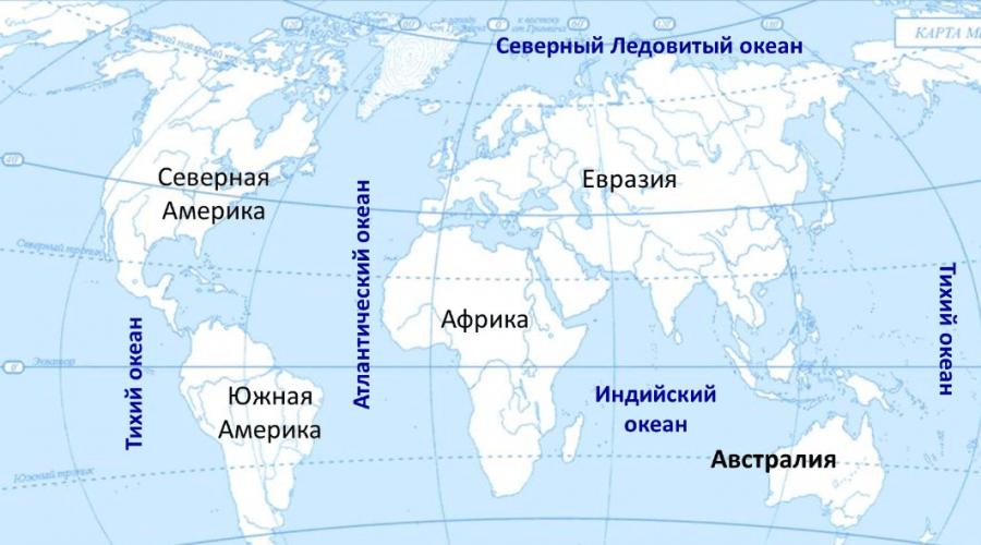
There are 92 sovereign states in Eurasia, 44 in Europe and 48 in Asia.

Rice. 1. Europe and Asia on the map
The name “Eurasia” itself comes from a combination of the parts of the world Europe and Asia, which are geographically located within the borders of the continent.
This name of the continent was first used by the famous geographer Alexander Humboldt. He did this in the first half of the 19th century.
TOP 4 articleswho are reading along with this
Today, many countries in Eurasia are popular destinations for tourists. There are enough places on the mainland with beautiful architecture that have survived to this day.
There is also rapid economic growth in a number of countries in the Asian region. An example of the rapid development of economic orientation can be considered using the example of the Chinese capital.
Beijing is the second largest metropolis in the world by population. The main objects of national importance are located here.
Many significant transport routes and highways arise from the metropolis. Beijing is the political and cultural capital of the people of China.

Rice. 2. Beijing.
The ancient history of the city dates back approximately three thousand years. The city is famous for its beautiful parks, monumental palaces and religious buildings.
The Chinese call Beijing Beijing, which literally means “northern capital”. Today it is a fairly modern city. This is easy to see if we take into account the fact that today China is a power with a high level of economic potential.
The countries of the Asian region have the highest percentage of active use of the latest digital technologies and developments made in this area over the past decade in everyday life.
Today we are witnessing global integration. The states of Eurasia strive for mutually beneficial cooperation in all spheres of life and activity of mankind. Unions and commonwealths of states are formed on the territory of the mainland. An example would be the emergence of the European Union. Close socio-political relations between states make it possible to use the natural potential of Eurasia with the greatest efficiency.
Eurasia is a continent that contains dwarf states on its “body”. Such states include: Vatican City, Luxembourg, Andorra, Malta, Liechtenstein, San Marino, Monaco, Brunei, Singapore, Bahrain, Maldives. Some of which are island-type states.

Rice. 3. Singapore.
For comparison, it is worth noting that Russia occupies almost half of Eurasia.
The Principality of Monaco is located on the Mediterranean coast and occupies only 2 square kilometers around a cliff overlooking the open sea.
List of Eurasian countries and their capitals
Europe
- Austria Vienna;
- Albania – Tirana;
- Andorra - Andorra - La Vella;
- Belarus – Minsk;
- Belgium - Brussels;
- Bulgaria - Sofia;
- Bosnia and Herzegovina - Sarajevo;
- Vatican - Vatican;
- Great Britain, London;
- Hungary - Budapest;
- Germany Berlin;
- Greece - Athens;
- Denmark – Copenhagen;
- Ireland - Dublin;
- Iceland – Reykjavik;
- Spain Madrid;
- Italy Rome;
- Latvia, Riga;
- Lithuania -Vilnius;
- Liechtenstein – Vaduz;
- Luxembourg - Luxembourg;
- Malta – Valletta;
- Macedonia – Skopje;
- Moldova – Chisinau;
- Monaco – Monte Carlo;
- Netherlands – Amsterdam;
- Norway – Oslo;
- Poland Warsaw;
- Portugal - Lisbon;
- Russia Moscow;
- Romania - Bucharest;
- San Marino – San Marino;
- Serbia - Belgrade;
- Slovakia – Bratislava;
- Slovenia – Ljubljana;
- Ukraine, Kyiv;
- Finland – Helsinki;
- France Paris;
- Croatia – Zagreb;
- Montenegro – Podgorica;
- Czech Republic, Prague;
- Switzerland – Bern;
- Sweden – Stockholm;
- Estonia - Tallinn;
Asia
- Azerbaijan, Baku;
- Armenia – Yerevan;
- Afghanistan - Kabul;
- Bangladesh - Dhaka;
- Bahrain – Manama;
- Brunei - Bandar Seri Begawan;
- Bhutan – Thimphu;
- East Timor – Dili;
- Vietnam – Hanoi;
- Georgia, Tbilisi;
- Egypt (partially) – Cairo;
- India - New Delhi;
- Indonesia – Jakarta;
- Israel – Tel Aviv;
- Jordan - Jerusalem;
- Iraq - Baghdad;
- Iran – Tehran;
- Yemen - Sana'a;
- Kazakhstan, Astana;
- Cambodia – Phnom Penh;
- Qatar – Doha;
- Cyprus – Nicosia;
- Kyrgyzstan – Bishkek;
- China - Beijing;
- DPRK - Pyongyang;
- Kuwait - Kuwait City;
- Laos – Vietiane;
- Lebanon – Beirut;
- Malaysia – Kuala Lumpur;
- Maldives - Male;
- Mongolia - Ulaanbaatar;
- Myanmar - Rangoon;
- Nepal - Kathmandu;
- UAE - Abu Dhabi;
- Oman – Muscat;
- Pakistan – Islamabad;
- Saudi Arabia - Riyadh;
- Syria - Damascus;
- Singapore - Singapore;
- Tajikistan - Dushanbe;
- Thailand -Bangkok;
- Turkmenistan – Ashgabat;
- Türkiye - Ankara;
- Uzbekistan – Tashkent;
- Philippines - Manila;
- Sri Lanka - Colombo;
- Republic of Korea - Seoul;
- Japan Tokyo.
Peninsula countries of Eurasia
The peninsular states located on the territory of Eurasia include:
- Norway;
- Denmark;
- Spain;
- Portugal;
- Italy;
- Greece;
- India;
- Saudi Arabia;
- Malaysia;
- Thailand;
- Vietnam;
- DPRK;
- Republic of Korea;
- Malta.
Translated from the ancient Phoenician dialect, the name Malta means refuge or harbor. The island received its name due to its location at the crossroads of trade routes from Asia to European countries. About half a million people now live in Malta.
What have we learned?
We found out who first called the continent by its generally accepted name. We got an idea of which continental countries are rapidly gaining momentum in the direction of economic growth and development. We received information about the island states of Eurasia. We learned for what purpose European states are striving for unification.
Test on the topic
Evaluation of the report
Average rating: 4 . Total ratings received: 340.